vessel '636020904' IMO: 9341794, vesseltracker.com
Vessel '636020904' IMO: 9341794,
MMSI: 636020904 callsign: size: x

Find the position of the vessel '636020904' on the map. The latter are known coordinates and path.

marine traffic ship tracker show on live map

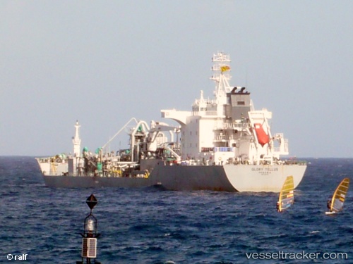
The current position of vessel '636020904' is -4.95908 lat / -35.1466 lng. Updated: 2024-04-19 19:47:14 UTC
Payload_mass:
20200 tonne
Gross tonnage:
12047
Service entry:
2006-01-01T00:00:00Z
Details:


Last coordinates of the vessel:
UTC, -5.44108, -34.8895, course: 330, speed: 11.4
UTC, -5.06935, -35.0869, course: 333, speed: 11.4
UTC, -5.00738, -35.1202, course: 333, speed: 11.5
2024-04-19 19:47:14 UTC, -4.95908, -35.1466, course: 332, speed: 11.5

Track of the vessel in the last 14 days


Most frequent ports a vessels calls at '636020904' (636020904):

Fortaleza, traffic: 14
Santana, traffic: 9
Algeciras, traffic: 2
Strait Of Gibraltar, traffic: 2
Manaus, traffic: 1

Link to the map:


Find another ship

'636020904' (636020904) last ports (portcalls and passsages)

Fortaleza | 2024-01-06 10:35:48
Santana | 2024-01-02 23:14:37
Fortaleza | 2023-12-12 22:07:45
Santana | 2023-12-08 20:27:36
Manaus | 2022-12-29 23:50:36
Fortaleza | 2022-12-12 14:14:32
Santana | 2022-11-26 02:12:36
Fortaleza | 2022-11-14 12:04:37
Fortaleza | 2022-10-15 10:23:56
Fortaleza | 2022-09-19 16:56:01
Santana | 2022-09-04 16:53:39
Fortaleza | 2022-08-25 10:55:45
Fortaleza | 2022-08-01 04:07:26
Santana | 2022-07-28 16:48:08
Fortaleza | 2022-07-01 22:56:13
Santana | 2022-06-28 13:10:17
Fortaleza | 2022-06-02 01:19:48
Santana | 2022-05-19 07:12:17
Fortaleza | 2022-05-08 04:30:24
Fortaleza | 2022-04-09 06:31:27
Santana | 2022-04-05 20:56:11
Fortaleza | 2022-02-11 12:51:01
Algeciras | 2022-02-01 04:55:07
Strait Of Gibraltar | 2022-01-31 13:45:13