 Celine
Current Status
Where is the vessel?
Celine is currently in 54 nm NW of Town Quays/Drogheda, based on AIS data received about 14h ago.
Latest AIS update:
Current position: 54.44856° N, 5.44980° E (54 nm NW of Town Quays/Drogheda)
Average speed (last 7 days): Loading…
Average speed (last 30 days): Loading…
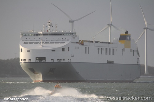
Vessel profile: Celine is a Ro Ro Cargo Ship with dimensions 234m x 38m.
This page combines live AIS, route history, probable destination signals, nearby traffic, and port activity for practical vessel monitoring.
The current position of vessel Celine is 54.44856 lat / 5.44980 lng. Updated: 2026-05-24 00:15:23 UTCNearest reference points:
- 14 nm NW of Town Quays/Drogheda
- Near HARLINGEN
- Near FRANEKER
Currently sailing under the flag of Malta ![]()
Details:
Live Vessel Celine Analytics (details, animations, etc.)
Recent AIS points (UTC):
2026-05-23 20:21:23 UTC · 53.41733, 4.69844 · SOG 17.5 kn · COG 31°2026-05-23 22:24:41 UTC · 53.97212, 5.06517 · SOG 17.4 kn · COG 20°
2026-05-23 23:06:16 UTC · 54.15534, 5.19249 · SOG 17.2 kn · COG 26°
2026-05-24 00:15:23 UTC · 54.44856, 5.44980 · SOG 17.4 kn · COG 26°