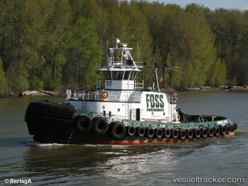
 DANIEL FOSS
Current Status
Where is the vessel?
DANIEL FOSS is currently in Near Tacoma, based on AIS data received about 14h ago.
Latest AIS update:
Current position: 47.26282° N, 122.43262° W (Near Tacoma)
Average speed (last 7 days): Loading…
Average speed (last 30 days): Loading…
Vessel profile: DANIEL FOSS is a Tug with dimensions m x m.
This page combines live AIS, route history, probable destination signals, nearby traffic, and port activity for practical vessel monitoring.
The current position of vessel DANIEL FOSS is 47.26282 lat / -122.43262 lng. Updated: 2026-05-23 13:02:30 UTCNearest reference points:
- Near Tacoma
- Near Fife
- Near Fox Island
Currently sailing under the flag of United States ![]()
Details:
Live Vessel DANIEL FOSS Analytics (details, animations, etc.)
Recent AIS points (UTC):
2026-05-23 10:17:28 UTC · 47.26283, -122.43263 · SOG 0 kn · COG 342°2026-05-23 10:38:23 UTC · 47.26283, -122.43263 · SOG 0 kn · COG 340°
2026-05-23 11:56:28 UTC · 47.26282, -122.43264 · SOG 0 kn · COG 338°
2026-05-23 13:02:30 UTC · 47.26282, -122.43262 · SOG 0 kn · COG 340°