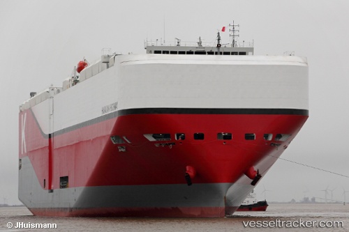
Hawaiian Highway
Current StatusWhere is the vessel?
Hawaiian Highway is currently in 93 nm W of Wolfersdorf, based on AIS data received about 14h ago.
Latest AIS update:
Current position: 48.97500° N, 14.01667° W (93 nm W of Wolfersdorf)
Average speed (last 7 days): Loading…
Average speed (last 30 days): Loading…
Vessel profile: Hawaiian Highway is a Vehicles Carrier with dimensions 40m x 199m.
This page combines live AIS, route history, probable destination signals, nearby traffic, and port activity for practical vessel monitoring.
The current position of vessel Hawaiian Highway is 48.97500 lat / -14.01667 lng. Updated: 2026-05-23 13:56:13 UTCNearest reference points:
- 24 nm N of Aurach Bei Kitzbuhel
- 20 nm SE of Wunschendorf
Details:
Live Vessel Hawaiian Highway Analytics (details, animations, etc.)
Recent AIS points (UTC):
2026-05-23 11:11:13 UTC · 48.89333, -14.81500 · SOG 11 kn · COG -1°2026-05-23 11:34:23 UTC · 48.90618, -14.70577 · SOG 11.3 kn · COG -1°
2026-05-23 13:32:16 UTC · 48.96500, -14.13500 · SOG 11 kn · COG -1°
2026-05-23 13:56:13 UTC · 48.97500, -14.01667 · SOG 11 kn · COG -1°