 PRINCESS BOA
Current Status
Where is the vessel?
PRINCESS BOA is currently in 24 nm E of Claonaig, based on AIS data received about 14h ago.
Latest AIS update:
Current position: 55.71271° N, 6.08153° E (24 nm E of Claonaig)
Average speed (last 7 days): Loading…
Average speed (last 30 days): Loading…
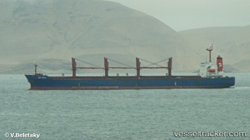
Vessel profile: PRINCESS BOA is a Bulk Carrier with dimensions 33m x 190m.
This page combines live AIS, route history, probable destination signals, nearby traffic, and port activity for practical vessel monitoring.
The current position of vessel PRINCESS BOA is 55.71271 lat / 6.08153 lng. Updated: 2026-05-23 17:35:40 UTCNearest reference points:
- 36 nm W of HVIDE SANDE
- Near Blavand
- 14 nm NW of Town Quays/Drogheda
Currently sailing under the flag of Marshall Islands ![]()
PRINCESS BOA built in 2003 year
Deadweight:
50337 tDetails:
Live Vessel PRINCESS BOA Analytics (details, animations, etc.)
Recent AIS points (UTC):
2026-05-23 14:12:53 UTC · 56.27180, 6.65780 · SOG 11.7 kn · COG 212°2026-05-23 15:54:40 UTC · 55.98819, 6.36364 · SOG 11.4 kn · COG 211°
2026-05-23 16:00:10 UTC · 55.97167, 6.34667 · SOG 11 kn · COG -1°
2026-05-23 17:35:40 UTC · 55.71271, 6.08153 · SOG 11.1 kn · COG 209°