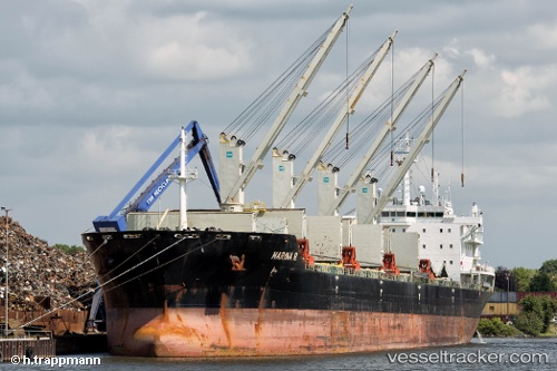
 MARINA R
Current Status
Where is the vessel?
MARINA R is currently in 156 nm W of Saldanha Bay, based on AIS data received about 14h ago.
Latest AIS update:
Current position: 33.73000° S, 14.85333° E (156 nm W of Saldanha Bay)
Average speed (last 7 days): Loading…
Average speed (last 30 days): Loading…
Vessel profile: MARINA R is a Bulk Carrier with dimensions m x m.
This page combines live AIS, route history, probable destination signals, nearby traffic, and port activity for practical vessel monitoring.
The current position of vessel MARINA R is -33.73000 lat / 14.85333 lng. Updated: 2026-05-23 13:16:54 UTCNearest reference points:
- 116 nm SW of Saldanha Bay
- 111 nm W of Kommetjie
- 167 nm SW of Koiingnaas
Currently sailing under the flag of Marshall Islands ![]()
Details:
Live Vessel MARINA R Analytics (details, animations, etc.)
Recent AIS points (UTC):
2026-05-23 10:18:27 UTC · -33.90287, 15.39984 · SOG 9.6 kn · COG 288°2026-05-23 10:18:58 UTC · -33.90244, 15.39827 · SOG 9.6 kn · COG 289°
2026-05-23 12:22:54 UTC · -33.78333, 15.02167 · SOG 9 kn · COG -1°
2026-05-23 13:16:54 UTC · -33.73000, 14.85333 · SOG 10 kn · COG -1°