 VELSHEDA
Current Status
Where is the vessel?
VELSHEDA is currently in 51 nm E of LA PALOMA, based on AIS data received about 14h ago.
Latest AIS update:
Current position: 34.71030° S, 53.11340° W (51 nm E of LA PALOMA)
Average speed (last 7 days): Loading…
Average speed (last 30 days): Loading…
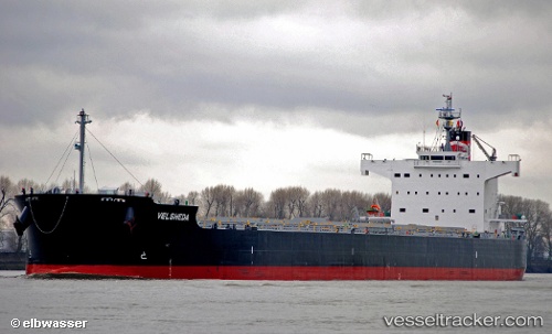
Vessel profile: VELSHEDA is a Bulk Carrier with dimensions 32m x 229m.
This page combines live AIS, route history, probable destination signals, nearby traffic, and port activity for practical vessel monitoring.
The current position of vessel VELSHEDA is -34.71030 lat / -53.11340 lng. Updated: 2026-05-24 01:24:47 UTCNearest reference points:
- 55 nm SE of Chui
- 75 nm SE of LA PALOMA
- 105 nm SE of Chui
Currently sailing under the flag of Liberia ![]()
VELSHEDA built in 2012 year
Deadweight:
82172 tDetails:
Live Vessel VELSHEDA Analytics (details, animations, etc.)
Recent AIS points (UTC):
2026-05-23 22:12:38 UTC · -34.72833, -52.37667 · SOG 10 kn · COG -1°2026-05-23 23:24:39 UTC · -34.72167, -52.62667 · SOG 10 kn · COG -1°
2026-05-24 01:00:41 UTC · -34.71167, -53.01167 · SOG 12 kn · COG -1°
2026-05-24 01:24:47 UTC · -34.71030, -53.11340 · SOG 12.5 kn · COG 268°