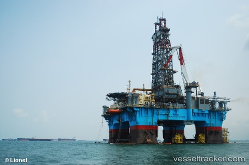
 NOBLE DISCOVERER
Current Status
Where is the vessel?
NOBLE DISCOVERER is currently in 37 nm W of Camarones, based on AIS data received about 14h ago.
Latest AIS update:
Current position: 11.58486° N, 73.64642° W (37 nm W of Camarones)
Average speed (last 7 days): Loading…
Average speed (last 30 days): Loading…
Vessel profile: NOBLE DISCOVERER is a Drilling Rig with dimensions m x m.
This page combines live AIS, route history, probable destination signals, nearby traffic, and port activity for practical vessel monitoring.
The current position of vessel NOBLE DISCOVERER is 11.58486 lat / -73.64642 lng. Updated: 2026-05-23 18:06:24 UTCNearest reference points:
- 18 nm N of Santa Marta
- Near Santa Marta
- Near PUERTO BOLIVAR
Currently sailing under the flag of Marshall Islands ![]()
Details:
Live Vessel NOBLE DISCOVERER Analytics (details, animations, etc.)
Recent AIS points (UTC):
2026-05-23 13:32:31 UTC · 11.58333, -73.64500 · SOG 0 kn · COG -1°2026-05-23 13:38:32 UTC · 11.58333, -73.64500 · SOG 0 kn · COG -1°
2026-05-23 15:29:35 UTC · 11.58333, -73.64500 · SOG 0 kn · COG -1°
2026-05-23 18:06:24 UTC · 11.58486, -73.64642 · SOG 0.1 kn · COG 54°