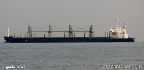
Matakana Island
Current StatusWhere is the vessel?
Matakana Island is currently in 13 nm SW of Incheon, based on AIS data received about 14h ago.
Latest AIS update:
Current position: 37.31651° N, 126.40600° E (13 nm SW of Incheon)
Average speed (last 7 days): Loading…
Average speed (last 30 days): Loading…
Vessel profile: Matakana Island is a Bulk Carrier with dimensions 30m x 175m.
This page combines live AIS, route history, probable destination signals, nearby traffic, and port activity for practical vessel monitoring.
The current position of vessel Matakana Island is 37.31651 lat / 126.40600 lng. Updated: 2026-05-23 23:59:01 UTCNearest reference points:
- 14 nm SW of Incheon
- 10 nm N of DAESAN
- Near Incheon
Details:
Live Vessel Matakana Island Analytics (details, animations, etc.)
Recent AIS points (UTC):
2026-05-23 19:47:01 UTC · 37.31519, 126.40300 · SOG 0.2 kn · COG 76°2026-05-23 21:38:01 UTC · 37.31662, 126.40593 · SOG 0.1 kn · COG 215°
2026-05-23 23:02:01 UTC · 37.31646, 126.40616 · SOG 0.1 kn · COG 213°
2026-05-23 23:59:01 UTC · 37.31651, 126.40600 · SOG 0 kn · COG 207°