 MDS ARTEMIS
Current Status
Where is the vessel?
MDS ARTEMIS is currently in 88 nm SW of Georgetown, Grand Cayman, based on AIS data received about 14h ago.
Latest AIS update:
Current position: 18.65167° N, 82.77167° W (88 nm SW of Georgetown, Grand Cayman)
Average speed (last 7 days): Loading…
Average speed (last 30 days): Loading…
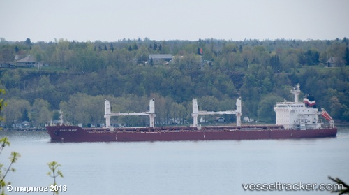
Vessel profile: MDS ARTEMIS is a Bulk Carrier with dimensions m x m.
This page combines live AIS, route history, probable destination signals, nearby traffic, and port activity for practical vessel monitoring.
The current position of vessel MDS ARTEMIS is 18.65167 lat / -82.77167 lng. Updated: 2026-05-23 22:27:55 UTCNearest reference points:
- Near Georgetown, Grand Cayman
- 58 nm S of San Julian
Currently sailing under the flag of Marshall Islands ![]()
Details:
Live Vessel MDS ARTEMIS Analytics (details, animations, etc.)
Recent AIS points (UTC):
2026-05-23 19:09:56 UTC · 18.09833, -82.26167 · SOG 13 kn · COG -1°2026-05-23 20:21:52 UTC · 18.29833, -82.44500 · SOG 13 kn · COG -1°
2026-05-23 21:39:54 UTC · 18.51167, -82.65500 · SOG 13 kn · COG -1°
2026-05-23 22:27:55 UTC · 18.65167, -82.77167 · SOG 13 kn · COG -1°