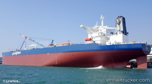
 KHURAIS
Current Status
Where is the vessel?
KHURAIS is currently in 340 nm SE of Abakaliki, based on AIS data received about 14h ago.
Latest AIS update:
Current position: 1.86209° N, 89.49301° E (340 nm SE of Abakaliki)
Average speed (last 7 days): Loading…
Average speed (last 30 days): Loading…
Vessel profile: KHURAIS is a Tanker with dimensions m x m.
This page combines live AIS, route history, probable destination signals, nearby traffic, and port activity for practical vessel monitoring.
The current position of vessel KHURAIS is 1.86209 lat / 89.49301 lng. Updated: 2026-05-24 00:19:14 UTCNearest reference points:
- Open sea, approx. 401 nm off the nearest listed port
- Open sea, approx. 402 nm off the nearest listed port
- Open sea, approx. 404 nm off the nearest listed port
Currently sailing under the flag of Saudi Arabia ![]()
Details:
Live Vessel KHURAIS Analytics (details, animations, etc.)
Recent AIS points (UTC):
2026-05-23 19:13:30 UTC · 2.52717, 90.11366 · SOG 10.9 kn · COG 221°2026-05-23 21:43:55 UTC · 2.18385, 89.82352 · SOG 10.5 kn · COG -1°
2026-05-23 22:39:16 UTC · 2.06580, 89.71118 · SOG 10.6 kn · COG -1°
2026-05-24 00:19:14 UTC · 1.86209, 89.49301 · SOG 10.9 kn · COG 229°