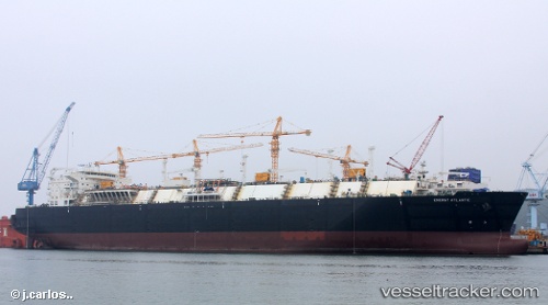
vessel Energy Atlantic IMO: 9649328, Lng Tanker
vesseltracker.com
Vessel Energy Atlantic IMO: 9649328, Lng Tanker
MMSI: 256647000 callsign: 9HA3976 size: 290x290

Find the position of the vessel Energy Atlantic on the map. The latter are known coordinates and path.

marine traffic ship tracker show on live map

The current position of vessel Energy Atlantic is 20.59108 lat / 120.58724 lng. Updated: 2025-11-02 09:57:57 UTC

Currently sailing under the flag of Malta

Details:


Last coordinates of the vessel:
UTC, 20.93846, 120.94323, course: 225, speed: 9.4
UTC, 20.87632, 120.85960, course: 212, speed: 9.3
UTC, 20.71331, 120.71939, course: 205, speed: 8.8
2025-11-02 09:57:57 UTC, 20.59108, 120.58724, course: 229, speed: 9.1

Most frequent ports a vessels calls at Energy Atlantic (256647000):

Sambu, traffic: 12
Singapore, traffic: 8
Freeport, traffic: 7
Malabo, traffic: 6
BATU AMPAR, traffic: 5
BUKOM ISLAND, traffic: 4
TANAH MERAH, traffic: 4
Algeciras, traffic: 4
PULAU SAMBU, traffic: 3
Huelva, traffic: 3
Strait Of Gibraltar, traffic: 3
Osaka, traffic: 3
Colon, traffic: 3
Panama, traffic: 3
Cristobal, traffic: 3

Link to the map:


Find another ship

Energy_Atlantic (256647000) last ports (portcalls and passsages)

West Coast Town | 2025-09-08 21:32:07
Nipah | 2025-09-08 17:31:34
BUKOM ISLAND | 2025-09-08 11:06:16
Barrow Island | 2025-08-18 05:29:06
Yokohama | 2025-07-27 03:58:46
KIMITSU | 2025-07-26 02:59:31
Yokosuka | 2025-07-26 01:58:37
BINTULU | 2025-07-07 13:13:40
TANAH MERAH | 2025-06-03 04:20:54
Das Island | 2025-05-10 20:24:29
Fateh Terminal | 2025-05-09 21:13:53
DAHEJ | 2025-04-20 20:43:39
Das Island | 2025-04-14 03:52:13
Fateh Terminal | 2025-04-13 16:03:15
DAHEJ | 2025-04-08 07:26:20
Das Island | 2025-03-13 19:36:41
BATU AMPAR | 2025-02-10 05:50:22
PENGERANG | 2025-02-10 04:58:51
YUNG AN | 2025-02-03 23:52:58
TANAH MERAH | 2025-01-28 03:34:09
PULAU SAMBU | 2025-01-28 02:47:10
BUKOM ISLAND | 2025-01-25 20:26:04
BUKOM ISLAND | 2025-01-04 01:24:58
BATU AMPAR | 2025-01-04 00:26:36
PENGERANG | 2025-01-03 22:53:12
TANAH MERAH | 2024-12-17 16:52:57
Galle | 2024-12-01 03:25:41
BUKOM ISLAND | 2024-11-23 21:21:45
BATU AMPAR | 2024-11-23 20:10:33
TANAH MERAH | 2024-11-23 19:04:04
PENGERANG | 2024-11-23 18:24:30
Singapore | 2024-10-26 04:11:56
Singapore | 2024-10-05 15:19:53
Gladstone Harbor | 2024-09-10 19:35:41
Osaka | 2024-08-19 22:39:12
Singapore | 2024-08-07 21:06:57
Freeport | 2024-07-02 14:11:22
Port Des Galets | 2024-06-01 09:38:46
Singapore | 2024-05-22 06:36:33
Sambu | 2024-05-22 05:36:04
Osaka | 2024-05-14 00:07:10
Port Des Galets | 2024-02-16 04:49:21
Sambu | 2024-02-07 02:50:06
Higashi-Iwase | 2024-01-29 22:20:10
Panama | 2024-01-05 20:34:55
Rodman | 2024-01-05 18:04:29
Cristobal | 2024-01-05 09:08:04
Freeport | 2023-12-21 09:37:41
Strait Of Gibraltar | 2023-12-08 13:23:18
St. Louis Du Rhone | 2023-12-05 07:08:17
Calais | 2023-10-16 13:06:34
Calais | 2023-10-09 06:59:41
Cristobal | 2023-08-20 19:27:45
Rodman | 2023-08-20 09:14:33
Panama | 2023-08-19 23:24:42
Osaka | 2023-07-26 00:14:28
Panama | 2023-06-30 23:02:31
Rodman | 2023-06-30 19:32:29
Cristobal | 2023-06-29 14:16:40
Freeport | 2023-06-16 10:32:59
Huelva | 2023-05-14 21:45:43
Freeport | 2023-04-03 23:08:34
Freeport | 2023-01-30 15:00:06
Huelva | 2023-01-14 05:51:24
Freeport | 2022-12-19 17:41:09
Freeport | 2022-12-10 14:08:48
Algeciras | 2022-10-27 19:29:15
Algeciras | 2022-10-23 16:59:19
Strait Of Gibraltar | 2022-09-10 19:31:15
Algeciras | 2022-09-09 22:51:37
Huelva | 2022-07-20 07:11:00
Strait Of Gibraltar | 2022-07-18 08:09:47
Algeciras | 2022-07-17 19:41:30
Port Des Galets | 2022-04-22 06:25:41
Sambu | 2022-03-25 12:55:19
Ras Gharib | 2022-03-12 00:22:17
Bur Ibrahim | 2022-03-11 16:00:10
Port Said | 2022-03-11 06:16:21
Urdiales | 2022-02-12 18:50:41
Malabo | 2022-01-29 11:16:03
Malabo | 2022-01-29 10:36:13
Malabo | 2022-01-29 07:40:53
Milford Haven | 2022-01-11 13:35:14