vessel Levanger IMO: 6827606, Passenger Ro Ro Cargo Ship
vesseltracker.com
Vessel Levanger IMO: 6827606, Passenger Ro Ro Cargo Ship
MMSI: 257046700 callsign: LAJK size: 50x12

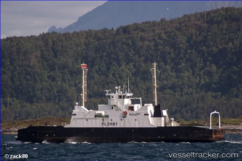
Find the position of the vessel Levanger on the map. The latter are known coordinates and path.

marine traffic ship tracker show on live map

The current position of vessel Levanger is 63.751365 lat / 11.297328333333 lng. Updated: 2025-09-13 08:08:31 UTC

Currently sailing under the flag of Norway

Levanger built in 1968 year

Deadweight:
165 t

Details:


Last coordinates of the vessel:
UTC, 63.751428333333, 11.297275, course: 120, speed: 0
UTC, 63.75138, 11.297308333333, course: 120, speed: 0
UTC, 63.75141, 11.297318333333, course: 120, speed: 0
2025-09-13 08:08:31 UTC, 63.751365, 11.297328333333, course: 119, speed: 0

Track of the vessel in the last 14 days


Most frequent ports a vessels calls at Levanger (257046700):

Trondheim, traffic: 10
Levanger, traffic: 1
Skogn, traffic: 1
Verdal, traffic: 1

Link to the map:


Find another ship

Levanger (257046700) last ports (portcalls and passsages)

Verdal | 2025-09-05 23:51:48
Trondheim | 2025-02-04 16:33:05
Trondheim | 2025-01-31 15:51:20
Trondheim | 2025-01-27 15:46:00
Trondheim | 2025-01-23 15:24:46
Trondheim | 2025-01-19 15:06:42
Trondheim | 2025-01-15 13:51:03
Trondheim | 2025-01-11 13:40:14
Trondheim | 2025-01-07 12:46:54
Trondheim | 2025-01-03 11:42:46
Trondheim | 2024-12-30 11:38:50