.
vessel WESTMORE IMO: 9289788, Chemical/Oil Products Tanker vesseltracker.com
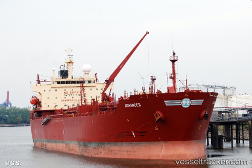
Vessel WESTMORE IMO: 9289788, MMSI: 538008821 Chemical/Oil Products Tanker

callsign: V7A2800
size: 32x183

Live AIS position: UTC. 262 nm S of Floreana Island), updated 2025-12-23 09:15:54 UTC.

Find the position of the vessel WESTMORE on the map. The latter are known coordinates and path.

marine traffic ship tracker show on live map

The current position of vessel WESTMORE is -5.64427 lat / -90.78890 lng. Updated: 2025-12-23 09:15:54 UTC

Currently sailing under the flag of Marshall Islands

WESTMORE built in 2006 year

Deadweight:
46101 t

Details:


Last coordinates of the vessel:
2025-12-23 09:15:54 UTC, -5.64427, -90.78890, course: 0, speed: 34.3

Track of the vessel in the last 28 days


Most frequent ports a vessels calls at WESTMORE (538008821):

Apapa, traffic: 8
Burutu, traffic: 4
Lome, traffic: 3
Lagos, traffic: 2
Calabar, traffic: 1
Matadi, traffic: 1
Ningbo, traffic: 1
Ango Ango, traffic: 1
Banana, traffic: 1
Boma, traffic: 1

Link to the map:


Find another ship

WESTMORE (538008821) last ports (portcalls and passsages)

Ningbo | 2025-02-20 10:23:18
Burutu | 2023-03-20 05:36:16
Apapa | 2023-03-17 05:23:12
Banana | 2023-03-13 14:07:39
Matadi | 2023-03-09 11:02:49
Boma | 2023-03-05 05:28:18
Lome | 2023-02-27 23:17:38
Apapa | 2023-02-17 05:42:31
Burutu | 2023-02-16 14:32:32
Burutu | 2023-02-11 05:06:31
Apapa | 2023-02-10 14:58:03
Apapa | 2023-02-06 08:45:05
Burutu | 2023-02-01 06:10:11
Lome | 2023-01-29 08:40:46
Apapa | 2023-01-28 18:05:36
Lagos | 2023-01-28 14:41:42
Lagos | 2023-01-24 14:20:27
Apapa | 2023-01-21 08:11:18
Apapa | 2023-01-13 05:19:34
Lome | 2023-01-11 20:08:26
Apapa | 2023-01-09 05:05:24
Calabar | 2023-01-03 11:02:37