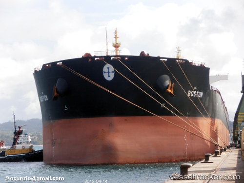
vessel Boston IMO: 9445966, Bulk Carrier
vesseltracker.com
Vessel Boston IMO: 9445966, Bulk Carrier
MMSI: 538002934 callsign: V7NA5 size: 292x45

Find the position of the vessel Boston on the map. The latter are known coordinates and path.

marine traffic ship tracker show on live map

The current position of vessel Boston is 26.4489 lat / 119.716 lng. Updated: 2025-07-05 18:03:36 UTC

Currently sailing under the flag of Marshall Is

Boston built in 2007 year

Port of registry:
Majuro (capital of the Marshall Islands)
Deadweight:
177827 t

Gross tonnage:
91373
Service entry:
2007-01-01T00:00:00Z

Manufacturer:
Shanghai Waigaoqiao Shipbuilding (shipyard in Shanghai, China)
Details:


Last coordinates of the vessel:
UTC, 26.4491, 119.716, course: 50, speed: 0
UTC, 26.449, 119.716, course: 50, speed: 0
2025-07-05 18:03:36 UTC, 26.4489, 119.716, course: 50, speed: 0

Track of the vessel in the last 14 days


Most frequent ports a vessels calls at Boston (538002934):

Sambu, traffic: 8
Singapore, traffic: 8
Whyalla, traffic: 4
Saldanha Bay, traffic: 4
Wu-Sung, traffic: 3
Fangcheng, traffic: 3
Port Louis, traffic: 3
Wusong, traffic: 3
TANAH MERAH, traffic: 3
PENGERANG, traffic: 3
LUOYUAN, traffic: 3
Mormugao, traffic: 2
BUKOM ISLAND, traffic: 2
PULAU SAMBU, traffic: 2
Port Elizabeth, traffic: 2

Link to the map:


Find another ship

Boston (538002934) last ports (portcalls and passsages)

LUOYUAN | 2025-07-02 05:48:04
LUOYUAN | 2025-06-26 06:16:10
LUOYUAN | 2025-06-20 19:45:17
Nantong | 2025-06-17 10:14:58
Zhangjiagang | 2025-06-15 02:22:31
Taicang | 2025-06-14 20:51:15
Wusong | 2025-06-14 18:47:23
Jingjiang | 2025-06-14 13:36:07
PENGERANG | 2025-06-01 08:48:50
TANAH MERAH | 2025-05-31 15:16:23
Sambu | 2025-05-31 13:59:04
Port Elizabeth | 2025-03-25 07:11:25
JURONG ISLAND | 2025-03-02 18:16:55
BUKOM ISLAND | 2025-03-02 17:20:17
TEKONG ISLAND | 2025-03-02 01:42:30
TANAH MERAH | 2025-03-01 22:32:30
PENGERANG | 2025-03-01 21:24:46
Bayuquan | 2025-02-16 21:57:43
HUANGHUA | 2025-02-14 09:25:41
PENGERANG | 2025-01-30 13:24:14
TANAH MERAH | 2025-01-29 05:20:04
BATU AMPAR | 2025-01-28 23:14:15
Sambu | 2025-01-28 22:04:46
BUKOM ISLAND | 2025-01-28 21:09:09
Port Louis | 2025-01-14 13:32:51
Port Elizabeth | 2024-11-15 13:54:32
Port Louis | 2024-11-06 20:19:41
Singapore | 2024-10-25 10:27:14
Rizhao | 2024-10-11 03:50:09
Selat Lombok | 2024-08-06 01:44:14
Whyalla | 2024-07-18 00:15:27
Whyalla | 2024-07-13 22:59:35
Panjang | 2024-07-02 11:43:16
Fangcheng | 2024-06-25 09:13:33
Fangcheng | 2024-06-21 08:55:46
Selat Lombok | 2024-04-19 05:22:13
Whyalla | 2024-03-30 01:21:58
Whyalla | 2024-03-26 00:04:19
Fangcheng | 2024-02-03 18:39:35
Singapore | 2024-01-25 17:47:08
Saldanha Bay | 2024-01-05 00:38:13
Saldanha Bay | 2023-12-29 05:09:08
Cape Town | 2023-12-28 03:34:46
Cape Town | 2023-12-24 03:12:18
Cape Of Good Hope | 2023-12-24 00:07:22
Sitrah Anchorage | 2023-11-30 15:56:02
Sitrah Anchorage | 2023-09-17 01:22:25
Sambu | 2023-07-07 22:21:50
Cai Mep | 2023-06-17 06:15:15
Vung Tau | 2023-06-17 04:05:47
Taicang | 2023-05-03 04:09:46
Wu-Sung | 2023-05-03 02:21:34
Singapore | 2023-04-21 20:44:24
Sebang | 2023-04-19 14:35:37
Sao Luiz | 2022-12-01 11:07:33
Ijmuiden | 2022-11-04 23:06:54
Richards Bay | 2022-09-13 13:52:03
Sambu | 2022-07-26 07:26:24
Port Hedland | 2022-05-05 19:04:08
Port Louis | 2022-03-12 12:49:47
Saldanha Bay | 2022-02-27 06:30:35
Marmagao | 2022-02-04 02:55:56
Singapore | 2022-01-21 00:05:43