 vesseltracker.com
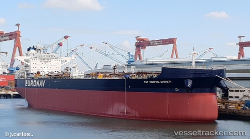
Vessel Cap Corpus Christi IMO: 9829813, MMSI: 241612000 Crude Oil Tanker
UTC, 48.83167, -68.08667, course: -1, speed: 14
UTC, 49.14778, -67.14844, course: 65, speed: 13.5
2026-02-07 21:40:42 UTC, 49.24532, -66.74002, course: 68, speed: 14
Live AIS position:
UTC. Near Cap-Chat),
updated 2026-02-07 21:40:42 UTC.
Find the position of the vessel Cap Corpus Christi on the map. The latter are known coordinates and path.
marine traffic ship tracker show on live map
The current position of vessel Cap Corpus Christi is 49.24532 lat / -66.74002 lng. Updated: 2026-02-07 21:40:42 UTCCurrently sailing under the flag of Greece
Details:
Last coordinates of the vessel:
UTC, 48.69500, -68.40167, course: -1, speed: 13UTC, 48.83167, -68.08667, course: -1, speed: 14
UTC, 49.14778, -67.14844, course: 65, speed: 13.5
2026-02-07 21:40:42 UTC, 49.24532, -66.74002, course: 68, speed: 14