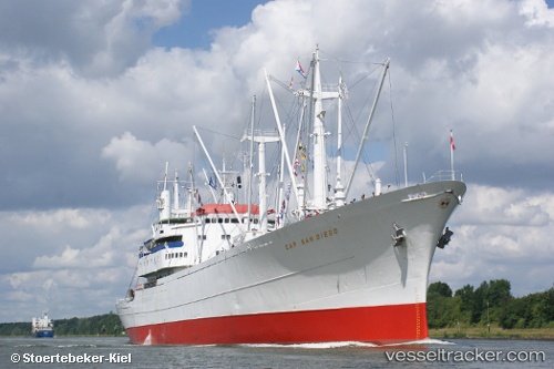
vessel Cap San Diego IMO: 5060794, Multi Purpose Carrier
vesseltracker.com
Vessel Cap San Diego IMO: 5060794, Multi Purpose Carrier
MMSI: 211855000 callsign: DNAI size: 160x20

Find the position of the vessel Cap San Diego on the map. The latter are known coordinates and path.

marine traffic ship tracker show on live map

The current position of vessel Cap San Diego is 53.5432 lat / 9.9762 lng. Updated: 2025-07-13 23:38:34 UTC

Currently sailing under the flag of Germany

Cap San Diego built in 1962 year

Deadweight:
10017 t

Details:


Last coordinates of the vessel:
UTC, 53.5432, 9.97617, course: 300, speed: 0
UTC, 53.5432, 9.97616, course: 300, speed: 0
2025-07-13 23:38:34 UTC, 53.5432, 9.9762, course: 300, speed: 0

Track of the vessel in the last 14 days


Most frequent ports a vessels calls at Cap San Diego (211855000):

Stadersand, traffic: 15
Cuxhaven, traffic: 5
Kiel, traffic: 3
Nord-Ostsee-Kanal, traffic: 3
WEDEL, traffic: 2
STADE, traffic: 2
Bremerhaven, traffic: 1

Link to the map:


Find another ship

Cap_San_Diego (211855000) last ports (portcalls and passsages)

STADE | 2025-06-21 17:33:38
Stadersand | 2025-06-21 16:35:19
WEDEL | 2025-06-21 16:24:27
STADE | 2025-05-10 09:59:35
Stadersand | 2024-09-14 10:55:49
Cuxhaven | 2024-08-24 13:32:09
Stadersand | 2024-08-24 09:53:29
Stadersand | 2024-07-21 12:56:53
Cuxhaven | 2024-07-20 17:25:44
Stadersand | 2024-06-29 12:13:15
Stadersand | 2024-05-09 10:45:14
Nord-Ostsee-Kanal | 2023-09-17 18:24:08
Stadersand | 2023-09-15 10:25:44
Stadersand | 2023-09-02 13:57:22
Stadersand | 2023-07-16 12:22:27
Cuxhaven | 2023-07-15 14:28:43
Stadersand | 2023-06-17 17:36:56
Stadersand | 2023-05-05 09:25:54
Nord-Ostsee-Kanal | 2022-08-10 13:56:09
Kiel | 2022-08-06 13:11:43
Stadersand | 2022-08-05 10:12:56
Stadersand | 2022-07-26 13:40:01
Cuxhaven | 2022-07-25 19:54:08
Bremerhaven | 2022-07-25 14:04:40
Cuxhaven | 2022-07-21 13:27:14
Stadersand | 2022-05-06 10:29:45