 vesseltracker.com
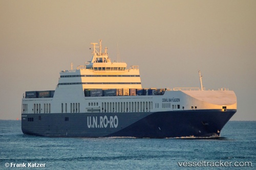
Vessel Cemil Bayulgen IMO: 9422134, MMSI: 271040948 Ro Ro Cargo Ship
UTC, 42.89262, 5.05486, course: 115, speed: 18.5
UTC, 41.28359, 9.56200, course: 119, speed: 19
2026-02-05 15:13:55 UTC, 41.09328, 9.97492, course: 120, speed: 18.7
Live AIS position:
UTC. 17 nm E of Golfo Aranci),
updated 2026-02-05 15:13:55 UTC.
Find the position of the vessel Cemil Bayulgen on the map. The latter are known coordinates and path.
marine traffic ship tracker show on live map
The current position of vessel Cemil Bayulgen is 41.09328 lat / 9.97492 lng. Updated: 2026-02-05 15:13:55 UTCCurrently sailing under the flag of Turkey
Cemil Bayulgen built in 2010 year
Deadweight:
11636 tDetails:
Last coordinates of the vessel:
UTC, 42.89262, 5.05486, course: 115, speed: 18.5UTC, 42.89262, 5.05486, course: 115, speed: 18.5
UTC, 41.28359, 9.56200, course: 119, speed: 19
2026-02-05 15:13:55 UTC, 41.09328, 9.97492, course: 120, speed: 18.7