 vesseltracker.com
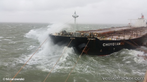
Vessel Chiyotamou IMO: 9335862, MMSI: 370021000 Ore Carrier
UTC, 7.63416, 111.00274, course: 18, speed: 9.3
UTC, 7.96167, 111.07500, course: -1, speed: 9
2026-01-28 18:10:24 UTC, 8.25667, 111.13667, course: -1, speed: 9
Live AIS position:
UTC. 49 nm NE of Colomadu),
updated 2026-01-28 18:10:24 UTC.
Find the position of the vessel Chiyotamou on the map. The latter are known coordinates and path.
marine traffic ship tracker show on live map
The current position of vessel Chiyotamou is 8.25667 lat / 111.13667 lng. Updated: 2026-01-28 18:10:24 UTCCurrently sailing under the flag of Panama
Chiyotamou built in 2008 year
Deadweight:
228627 tDetails:
Last coordinates of the vessel:
UTC, 7.21333, 110.89167, course: -1, speed: 9UTC, 7.63416, 111.00274, course: 18, speed: 9.3
UTC, 7.96167, 111.07500, course: -1, speed: 9
2026-01-28 18:10:24 UTC, 8.25667, 111.13667, course: -1, speed: 9