 vesseltracker.com
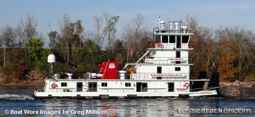
Vessel Cincinnati IMO: 8976499, MMSI: 366856460 Service Ship
UTC, 39.07772, -84.63157, course: -1, speed: 0
UTC, 39.07771, -84.63156, course: -1, speed: 0
2026-01-31 20:23:49 UTC, 39.07771, -84.63157, course: -1, speed: 0
Live AIS position:
UTC. Near Crestview Hills),
updated 2026-01-31 20:23:49 UTC.
Find the position of the vessel Cincinnati on the map. The latter are known coordinates and path.
marine traffic ship tracker show on live map
The current position of vessel Cincinnati is 39.07771 lat / -84.63157 lng. Updated: 2026-01-31 20:23:49 UTCCurrently sailing under the flag of USA
Details:
Last coordinates of the vessel:
UTC, 39.07772, -84.63157, course: -1, speed: 0UTC, 39.07772, -84.63157, course: -1, speed: 0
UTC, 39.07771, -84.63156, course: -1, speed: 0
2026-01-31 20:23:49 UTC, 39.07771, -84.63157, course: -1, speed: 0