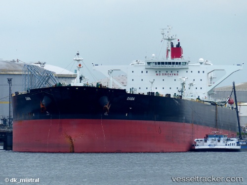
vessel Daba IMO: 9501162, Crude Oil Tanker
vesseltracker.com
Vessel Daba IMO: 9501162, Crude Oil Tanker
MMSI: 538004575 callsign: V7XU7 size: 333x333

Find the position of the vessel Daba on the map. The latter are known coordinates and path.

marine traffic ship tracker show on live map

The current position of vessel Daba is -23.4417 lat / 53.9267 lng. Updated: 2024-04-19 16:54:34 UTC

Currently sailing under the flag of Marshall Is

Daba built in 2012 year

Deadweight:
316373 t

Payload_mass:
316373 tonne
Gross tonnage:
162964
Service entry:
2012-01-01T00:00:00Z

Manufacturer:
Hyundai Mipo Dockyard (South Korean shipbuilding company)
Details:


Last coordinates of the vessel:
UTC, -23.6854, 53.4194, course: 67, speed: 11.5
UTC, -23.6317, 53.535, course: -1, speed: 12
UTC, -23.4517, 53.9067, course: -1, speed: 12
2024-04-19 16:54:34 UTC, -23.4417, 53.9267, course: -1, speed: 12

Track of the vessel in the last 14 days


Most frequent ports a vessels calls at Daba (538004575):

Sambu, traffic: 12
Singapore, traffic: 10
Angra Dos Reis, traffic: 5
Halul Island, traffic: 2
Dagu Bar, traffic: 1
Fujairah, traffic: 1
Ras Tannurah, traffic: 1
Taku Bar, traffic: 1

Link to the map:


Find another ship

Daba (538004575) last ports (portcalls and passsages)

Singapore | 2024-01-31 00:56:16
Angra Dos Reis | 2023-10-20 18:19:00
Taku Bar | 2023-08-23 09:05:46
Sambu | 2023-08-12 09:33:51
Angra Dos Reis | 2023-07-13 11:16:33
Angra Dos Reis | 2023-07-09 10:38:39
Sambu | 2023-06-08 03:11:23
Singapore | 2023-05-17 11:37:40
Singapore | 2023-04-18 10:14:03
Ras Tannurah | 2023-03-19 11:59:10
Singapore | 2023-02-03 11:58:09
Angra Dos Reis | 2023-01-02 14:24:28
Angra Dos Reis | 2022-12-29 06:04:35
Singapore | 2022-05-16 10:44:26
Fujairah | 2022-04-03 12:40:01
Halul Island | 2022-04-01 09:15:19
Sambu | 2022-01-10 19:30:54
Sambu | 2022-01-10 19:15:44
Singapore | 2021-12-07 06:50:32