 vesseltracker.com
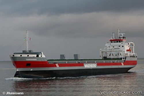
Vessel Ebroborg IMO: 9463451, MMSI: 245952000 General Cargo Ship
UTC, 55.75054, 12.72367, course: 132, speed: 0
UTC, 55.75072, 12.72417, course: -1, speed: 0
2026-03-08 05:27:23 UTC, 55.75084, 12.72456, course: -1, speed: 0
Live Vessel Ebroborg Analytics (details, animations, etc.)
Live AIS position: UTC. Near Klampenborg), updated 2026-03-08 05:27:23 UTC.Find the position of the vessel Ebroborg on the map. The latter are known coordinates and path.
marine traffic ship tracker show on live map
The current position of vessel Ebroborg is 55.75084 lat / 12.72456 lng. Updated: 2026-03-08 05:27:23 UTCCurrently sailing under the flag of Netherlands
Ebroborg built in 2010 year
Deadweight:
10750 tDetails:
Last coordinates of the vessel:
UTC, 55.75109, 12.72543, course: 180, speed: 0UTC, 55.75054, 12.72367, course: 132, speed: 0
UTC, 55.75072, 12.72417, course: -1, speed: 0
2026-03-08 05:27:23 UTC, 55.75084, 12.72456, course: -1, speed: 0