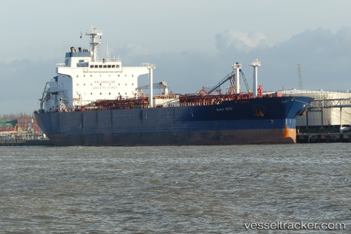
vessel Elka Bene IMO: 9234496, Chemical Oil Products Tanker
vesseltracker.com
Vessel Elka Bene IMO: 9234496, Chemical Oil Products Tanker
MMSI: 636012324 callsign: A8ES4 size: 189x32

Find the position of the vessel Elka Bene on the map. The latter are known coordinates and path.

marine traffic ship tracker show on live map

The current position of vessel Elka Bene is 19.9592 lat / 9.05563 lng. Updated: 2025-04-05 17:16:05 UTC

Currently sailing under the flag of Liberia

Elka Bene built in 2002 year

Deadweight:
45467 t

Payload_mass:
45467 tonne
Gross tonnage:
30770
Service entry:
2002-01-01T00:00:00Z

Manufacturer:
Brodosplit (Croatian shipyard)
Details:


Last coordinates of the vessel:
2025-04-05 17:16:05 UTC, 19.9592, 9.05563, course: 345, speed: 24.1

Track of the vessel in the last 14 days


Most frequent ports a vessels calls at Elka Bene (636012324):

Myrtle Grove, traffic: 4
New Orleans, traffic: 4
Ostrica, traffic: 4
Port Sulphur, traffic: 4
Ceuta, traffic: 2
Good Hope, traffic: 2
Strait Of Gibraltar, traffic: 2
Sao Luiz, traffic: 2
Port Said, traffic: 1

Link to the map:


Find another ship

Elka_Bene (636012324) last ports (portcalls and passsages)

Port Said | 2022-01-20 21:35:02
Ceuta | 2022-01-14 11:50:33
Strait Of Gibraltar | 2022-01-14 09:54:01
Sao Luiz | 2021-12-31 01:26:23
Ostrica | 2021-12-07 00:25:17
Port Sulphur | 2021-12-06 23:25:10
Myrtle Grove | 2021-12-06 22:00:19
New Orleans | 2021-12-06 19:26:44
Good Hope | 2021-12-04 18:15:08
New Orleans | 2021-12-03 19:51:28
Myrtle Grove | 2021-12-03 17:00:16
Port Sulphur | 2021-12-03 15:50:15
Ostrica | 2021-12-03 14:25:00