 vesseltracker.com
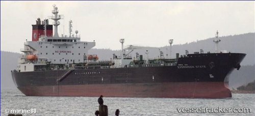
Vessel Evergreen State IMO: 9408138, MMSI: 367353070 Chemical Oil Products Tanker
UTC, 29.30595, -94.82521, course: 28, speed: 0
UTC, 29.30597, -94.82521, course: 28, speed: 0
2026-02-12 00:06:44 UTC, 29.30599, -94.82519, course: 28, speed: 0
Live AIS position:
UTC. Near Sheppard),
updated 2026-02-12 00:06:44 UTC.
Find the position of the vessel Evergreen State on the map. The latter are known coordinates and path.
marine traffic ship tracker show on live map
The current position of vessel Evergreen State is 29.30599 lat / -94.82519 lng. Updated: 2026-02-12 00:06:44 UTCCurrently sailing under the flag of USA
Evergreen State built in 2010 year
Deadweight:
48641 tDetails:
Last coordinates of the vessel:
UTC, 29.30598, -94.82521, course: 28, speed: 0UTC, 29.30595, -94.82521, course: 28, speed: 0
UTC, 29.30597, -94.82521, course: 28, speed: 0
2026-02-12 00:06:44 UTC, 29.30599, -94.82519, course: 28, speed: 0