vessel Folkestad IMO: 9347011, Passenger Ro Ro Cargo Ship
Vessel Folkestad IMO: 9347011, Passenger Ro Ro Cargo Ship
MMSI: 258266000 callsign: LNUJ size: 87x16

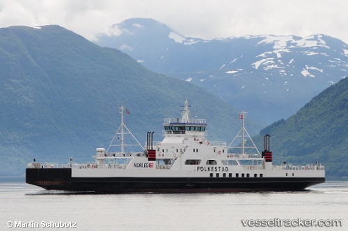
Find the position of the vessel Folkestad on the map. The latter are known coordinates and path.

marine traffic ship tracker show on live map

The current position of vessel Folkestad is 69.663 lat / 19.8082 lng. Updated: 2024-04-25 22:33:27 UTC

Currently sailing under the flag of Norway

Folkestad built in 2006 year

Port of registry:
Ålesund (town in Norway)
Deadweight:
655 t

Gross tonnage:
1910
Service entry:
2006-01-01T00:00:00Z

Manufacturer:
Remontowa (Polish shipyard)

Details:


Last coordinates of the vessel:
UTC, 69.663, 19.8082, course: 224, speed: 0
UTC, 69.663, 19.8082, course: 225, speed: 0
2024-04-25 22:33:27 UTC, 69.663, 19.8082, course: 225, speed: 0

Track of the vessel in the last 14 days


Most frequent ports a vessels calls at Folkestad (258266000):

Tromso, traffic: 6
Harstad, traffic: 1

Link to the map:


Find another ship

Folkestad (258266000) last ports (portcalls and passsages)

Harstad | 2023-05-26 18:28:49
Tromso | 2023-01-31 20:52:14
Tromso | 2022-11-05 11:56:50
Tromso | 2022-11-01 11:35:32
Tromso | 2022-06-11 04:25:04
Tromso | 2022-06-07 01:44:24
Tromso | 2022-06-03 01:27:36