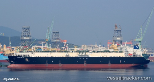
vessel Golar Igloo IMO: 9633991, Fsru Tanker
Vessel Golar Igloo IMO: 9633991, Fsru Tanker
MMSI: 538004977 callsign: V7AE6 size: 44x293

Find the position of the vessel Golar Igloo on the map. The latter are known coordinates and path.

marine traffic ship tracker show on live map

Port of registry:
Majuro (coral atoll, capital of the Marshall Islands)
Payload_mass:
87015 tonne
Gross tonnage:
106792
Service entry:
2014-01-01T00:00:00Z

Manufacturer:
Samsung Heavy Industries (South Korean shipbuilding company)
Details:


Track of the vessel in the last 14 days


Most frequent ports a vessels calls at Golar Igloo (538004977):

Algeciras, traffic: 4
Mutrah, traffic: 4
Strait Of Gibraltar, traffic: 2
Maassluis, traffic: 2
Sambu, traffic: 2
Malabo, traffic: 1
Cape Of Good Hope, traffic: 1
Cape Town, traffic: 1
Cochin, traffic: 1

Link to the map:


Find another ship

Golar_Igloo (538004977) last ports (portcalls and passsages)

Maassluis | 2022-09-01 10:49:42
Maassluis | 2022-08-28 10:32:52
Strait Of Gibraltar | 2022-07-06 10:10:06
Algeciras | 2022-07-06 01:27:44
Algeciras | 2022-06-30 10:25:33
Algeciras | 2022-06-26 07:35:56
Algeciras | 2022-06-22 07:31:54
Strait Of Gibraltar | 2022-06-22 04:11:06
Malabo | 2022-05-20 04:33:11
Cape Town | 2022-05-12 07:09:06
Cape Of Good Hope | 2022-05-12 01:27:09
Cochin | 2022-04-06 12:28:35
Mutrah | 2022-03-24 06:37:12
Sambu | 2022-02-15 12:27:34
Mutrah | 2022-01-18 02:36:45