vessel 'HARALD MAERSK' IMO: 9389502, vesseltracker.com
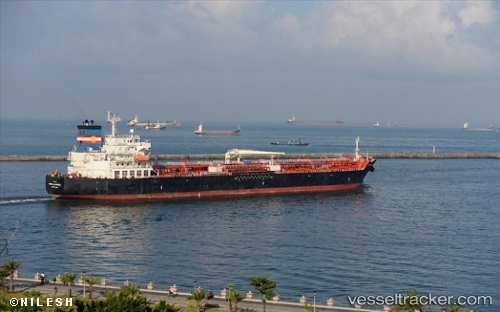
Vessel 'HARALD MAERSK' IMO: 9389502,
MMSI: 219279000 callsign: size: x

Find the position of the vessel 'HARALD MAERSK' on the map. The latter are known coordinates and path.

marine traffic ship tracker show on live map

The current position of vessel 'HARALD MAERSK' is 46.9473 lat / 31.9988 lng. Updated: 2023-05-06 10:00:05 UTC
Port of registry:
Svendborg (town on the south coast of Funen, Denmark)
Payload_mass:
37961 tonne
Gross tonnage:
25709
Service entry:
2009-01-01T00:00:00Z
Details:


Last coordinates of the vessel:
2023-05-06 10:00:05 UTC, 46.9473, 31.9988, course: -1, speed: 0

Track of the vessel in the last 14 days


Most frequent ports a vessels calls at 'HARALD MAERSK' (219279000):

Maassluis, traffic: 10
Vlaardingen, traffic: 6
Helsingor, traffic: 6
Uskudar, traffic: 3
Villagarcia, traffic: 2
Istanbul, traffic: 2
Kobenhavn, traffic: 2
Korsor, traffic: 2
Land Skrona, traffic: 2
Alexandria, traffic: 2
Canakkale, traffic: 2
Rotterdam, traffic: 2
Copenhagen, traffic: 2
Skagens Odde, traffic: 2
Gelibolu, traffic: 2

Link to the map:


Find another ship

'HARALD_MAERSK' (219279000) last ports (portcalls and passsages)

Uskudar | 2022-02-20 21:15:08
Gelibolu | 2022-02-19 04:00:57
Alexandria | 2022-02-08 08:23:00
Korsor | 2022-01-24 20:30:11
Kobenhavn | 2022-01-05 11:45:14
Land Skrona | 2022-01-05 11:15:46
Helsingor | 2022-01-05 10:55:04
Helsingborg | 2022-01-05 10:10:26
Helsingor | 2022-01-05 10:05:10
Skagens Odde | 2022-01-04 22:05:07
Maassluis | 2022-01-01 11:35:28
Vlaardingen | 2022-01-01 11:00:18
Maassluis | 2021-12-29 06:15:15
Maassluis | 2021-12-29 05:40:16
Maassluis | 2021-12-29 05:10:04
Villagarcia | 2021-12-22 03:20:24
Strait Of Gibraltar | 2021-12-20 05:15:25
Canakkale | 2021-12-12 15:00:03
Uskudar | 2021-12-10 19:40:06
Tandjung Uban | 2021-09-30 16:06:45