 vesseltracker.com
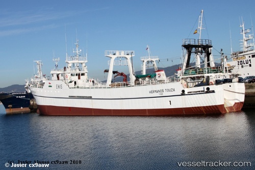
Vessel HERMANOS TOUZA IMO: 8513297, MMSI: 740410000 Fishing Vessel
UTC, -46.33537, -60.83109, course: 334, speed: 1.1
UTC, -46.25873, -60.84759, course: 343, speed: 4.9
2026-01-31 09:23:51 UTC, -46.10831, -60.82635, course: 6, speed: 4.9
Live AIS position:
UTC. 231 nm NE of Puerto Deseado),
updated 2026-01-31 09:23:51 UTC.
Find the position of the vessel HERMANOS TOUZA on the map. The latter are known coordinates and path.
marine traffic ship tracker show on live map
The current position of vessel HERMANOS TOUZA is -46.10831 lat / -60.82635 lng. Updated: 2026-01-31 09:23:51 UTCCurrently sailing under the flag of Falkland Islands
HERMANOS TOUZA built in 1986 year
Deadweight:
943 tDetails:
Last coordinates of the vessel:
UTC, -46.32594, -60.83617, course: 255, speed: 1.1UTC, -46.33537, -60.83109, course: 334, speed: 1.1
UTC, -46.25873, -60.84759, course: 343, speed: 4.9
2026-01-31 09:23:51 UTC, -46.10831, -60.82635, course: 6, speed: 4.9