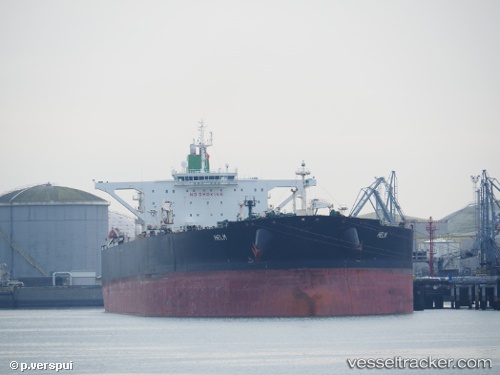
vessel Helm IMO: 9357391, Crude Oil Tanker
vesseltracker.com
Vessel Helm IMO: 9357391, Crude Oil Tanker
MMSI: 422208300 callsign: EPJF9 size: 333x333

Find the position of the vessel Helm on the map. The latter are known coordinates and path.

marine traffic ship tracker show on live map

The current position of vessel Helm is 25.61317 lat / 56.79017 lng. Updated: 2025-10-21 20:34:22 UTC

Currently sailing under the flag of Iran

Helm built in 2008 year

Deadweight:
317356 t

Details:


Last coordinates of the vessel:
2025-10-21 20:34:22 UTC, 25.61317, 56.79017, course: 8, speed: 13.8

Track of the vessel in the last 14 days


Most frequent ports a vessels calls at Helm (422208300):

Sambu, traffic: 17
Singapore, traffic: 13
PULAU SAMBU, traffic: 10
BATU AMPAR, traffic: 6
TANAH MERAH, traffic: 6
PENGERANG, traffic: 5
BUKOM ISLAND, traffic: 4
Galle, traffic: 1
JURONG ISLAND, traffic: 1

Link to the map:


Find another ship

Helm (422208300) last ports (portcalls and passsages)

PULAU SAMBU | 2025-09-14 12:22:43
JURONG ISLAND | 2025-08-06 01:12:36
PULAU SAMBU | 2025-08-06 00:05:15
TANAH MERAH | 2025-08-05 22:28:20
PENGERANG | 2025-07-27 08:06:29
PULAU SAMBU | 2025-07-27 06:21:16
BUKOM ISLAND | 2025-07-16 01:59:30
TANAH MERAH | 2025-07-16 00:37:03
PENGERANG | 2025-07-15 23:50:13
TANAH MERAH | 2025-06-28 16:09:12
PULAU SAMBU | 2025-06-28 15:07:51
BUKOM ISLAND | 2025-05-09 11:01:34
PENGERANG | 2025-04-18 08:49:26
TANAH MERAH | 2025-04-18 07:40:01
PULAU SAMBU | 2025-04-18 06:30:45
PULAU SAMBU | 2025-02-09 15:06:55
TANAH MERAH | 2025-02-09 14:20:14
PENGERANG | 2024-12-30 02:34:13
PULAU SAMBU | 2024-11-20 10:33:52
BATU AMPAR | 2024-11-20 09:44:04
TANAH MERAH | 2024-11-20 09:24:33
PENGERANG | 2024-11-04 16:48:43
BATU AMPAR | 2024-11-04 15:10:01
Galle | 2024-09-09 16:40:37
Sambu | 2024-08-20 02:40:34
Sambu | 2024-06-05 22:21:13
Singapore | 2023-12-26 17:13:15
Singapore | 2023-11-11 05:24:22
Singapore | 2023-08-25 09:46:21
Sambu | 2023-06-30 14:34:55
Singapore | 2023-06-08 18:16:49
Singapore | 2023-04-16 11:16:05