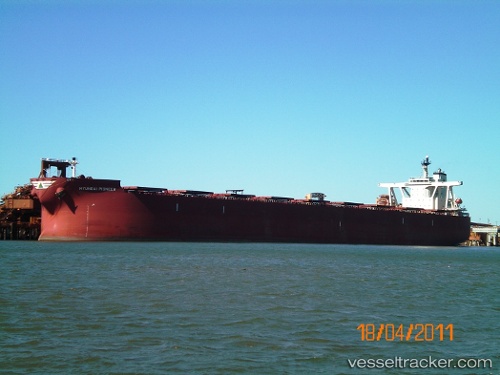
vessel Hyundai Pioneer IMO: 9398101, Ore Carrier
vesseltracker.com
Vessel Hyundai Pioneer IMO: 9398101, Ore Carrier
MMSI: 311019600 callsign: C6XQ9 size: 300x300

Find the position of the vessel Hyundai Pioneer on the map. The latter are known coordinates and path.

marine traffic ship tracker show on live map

The current position of vessel Hyundai Pioneer is -28.75188 lat / 52.47180 lng. Updated: 2025-10-29 06:48:07 UTC

Currently sailing under the flag of Bahamas

Details:


Last coordinates of the vessel:
UTC, -28.88792, 51.85132, course: 80, speed: 11.3
UTC, -28.85542, 51.99107, course: 83, speed: 11.2
UTC, -28.78692, 52.31825, course: 79, speed: 10.7
2025-10-29 06:48:07 UTC, -28.75188, 52.47180, course: 77, speed: 10.5

Track of the vessel in the last 14 days


Most frequent ports a vessels calls at Hyundai Pioneer (311019600):

Selat Lombok, traffic: 20
Port Walcot, traffic: 18
Samson Point, traffic: 18
Port Hedland, traffic: 11
Port Headland, traffic: 9
Sambu, traffic: 7
Singapore, traffic: 5
PENGERANG, traffic: 4
TANAH MERAH, traffic: 4
Yeosu, traffic: 3
Yosu, traffic: 3
Fangcheng, traffic: 2
Saldanha Bay, traffic: 2
BATU AMPAR, traffic: 2
BAKAUHENI, traffic: 2

Link to the map:


Find another ship

Hyundai_Pioneer (311019600) last ports (portcalls and passsages)

BUKOM ISLAND | 2025-08-21 13:34:35
BATU AMPAR | 2025-08-21 12:22:27
TANAH MERAH | 2025-08-20 14:38:39
PENGERANG | 2025-08-20 12:40:21
Antofagasta | 2025-07-26 11:57:16
BATU AMPAR | 2025-05-19 16:24:50
TANAH MERAH | 2025-05-18 15:26:41
PENGERANG | 2025-05-18 14:01:50
Fangcheng | 2025-05-11 17:15:44
Fangcheng | 2025-05-07 17:13:37
BAKAUHENI | 2025-04-27 15:14:12
JURONG ISLAND | 2025-02-07 06:41:58
Sambu | 2025-02-07 05:20:36
TANAH MERAH | 2025-02-06 11:17:13
PENGERANG | 2025-02-06 08:54:02
Lianyungang | 2025-01-26 07:53:41
Port Hedland | 2025-01-10 05:35:47
Selat Lombok | 2024-12-28 04:07:14
TANAH MERAH | 2024-12-23 23:15:37
PENGERANG | 2024-12-23 21:54:58
BAKAUHENI | 2024-11-25 22:49:40
Cape Of Good Hope | 2024-11-05 16:19:58
Singapore | 2024-09-13 20:59:28
Sambu | 2024-09-13 06:57:16
Singapore | 2024-08-24 05:57:49
Tubarao | 2024-07-17 17:21:17
Sambu | 2024-06-16 00:06:52
Yosu | 2024-04-24 00:20:24
Port Headland | 2024-04-03 14:21:02
Singapore | 2024-02-26 04:45:35
Sambu | 2023-12-15 07:36:43
Yosu | 2023-12-06 14:58:26
Yosu | 2023-11-27 16:58:33
Selat Lombok | 2023-11-04 06:19:24
Port Headland | 2023-10-30 19:25:51
Selat Lombok | 2023-09-25 19:45:49
Port Headland | 2023-09-22 01:03:23
Selat Lombok | 2023-08-12 22:27:07
Samson Point | 2023-08-06 13:37:10
Selat Lombok | 2023-08-04 04:33:21
Saldanha Bay | 2023-06-14 01:11:59
Saldanha Bay | 2023-06-08 16:58:55
Sambu | 2023-05-20 10:16:32
Selat Lombok | 2023-04-27 02:25:06
Port Headland | 2023-04-23 08:28:49
Selat Lombok | 2023-04-15 08:22:09
Samson Point | 2023-03-17 20:21:45
Samson Point | 2023-03-13 18:04:31
Selat Lombok | 2023-03-11 08:54:39
Port Walcot | 2023-02-11 00:02:17
Samson Point | 2023-02-06 23:35:11
Gladstone Harbor | 2022-12-13 03:02:49
Selat Lombok | 2022-11-08 23:25:03
Port Hedland | 2022-11-04 20:39:47
Samson Point | 2022-09-29 01:14:11
Samson Point | 2022-09-24 22:50:05
Samson Point | 2022-09-20 19:37:57
Port Walcot | 2022-09-16 19:30:29
Samson Point | 2022-09-12 17:09:59
Selat Lombok | 2022-09-10 07:04:27
Samson Point | 2022-08-12 10:50:32
Samson Point | 2022-08-08 10:27:55
Selat Lombok | 2022-07-08 22:05:56
Port Headland | 2022-07-05 04:16:05
Port Hedland | 2022-07-04 23:45:43
Selat Lombok | 2022-06-06 04:05:44
Samson Point | 2022-05-31 22:03:58
Samson Point | 2022-04-17 06:05:02
Selat Lombok | 2022-04-15 00:02:25
Samson Point | 2022-03-18 03:13:53
Selat Lombok | 2022-01-28 22:55:33
Port Hedland | 2022-01-24 12:10:00
Port Hedland | 2022-01-24 12:00:12
Selat Lombok | 2021-12-27 17:20:05
Port Walcot | 2021-12-11 08:35:13
Selat Lombok | 2021-12-09 00:01:34