 vesseltracker.com
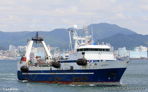
Vessel IOLANTA IMO: 8913289, MMSI: 273423800 Fishing Vessel
UTC, 49.62593, 156.35017, course: 234, speed: 6.2
UTC, 49.49638, 156.11795, course: -1, speed: 3.5
2026-03-05 04:13:03 UTC, 49.52552, 156.17834, course: 69, speed: 6.1
Live Vessel IOLANTA Analytics (details, animations, etc.)
Live AIS position: UTC. 28 nm E of Merin), updated 2026-03-05 04:13:03 UTC.Find the position of the vessel IOLANTA on the map. The latter are known coordinates and path.
marine traffic ship tracker show on live map
The current position of vessel IOLANTA is 49.52552 lat / 156.17834 lng. Updated: 2026-03-05 04:13:03 UTCCurrently sailing under the flag of Russia
IOLANTA built in 1992 year
Deadweight:
1258 tDetails:
Last coordinates of the vessel:
UTC, 49.51785, 156.10670, course: 230, speed: 4.4UTC, 49.62593, 156.35017, course: 234, speed: 6.2
UTC, 49.49638, 156.11795, course: -1, speed: 3.5
2026-03-05 04:13:03 UTC, 49.52552, 156.17834, course: 69, speed: 6.1