 vesseltracker.com
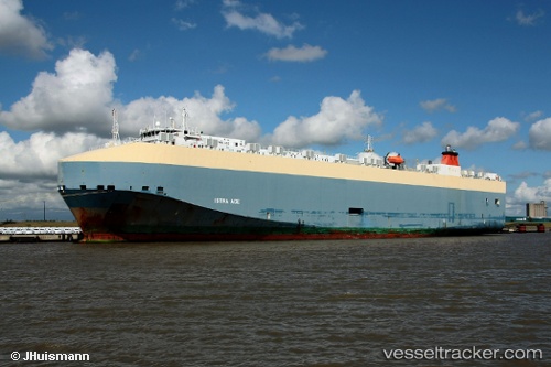
Vessel Istra Ace IMO: 9318503, MMSI: 309955000 Vehicles Carrier
UTC, 49.01856, -123.75890, course: 151, speed: 0.4
UTC, 49.01867, -123.75968, course: 197, speed: 0.3
2026-02-26 16:29:52 UTC, 49.01846, -123.75942, course: 189, speed: 0.1
Live AIS position:
UTC. Near Thetis Island),
updated 2026-02-26 16:29:52 UTC.
Find the position of the vessel Istra Ace on the map. The latter are known coordinates and path.
marine traffic ship tracker show on live map
The current position of vessel Istra Ace is 49.01846 lat / -123.75942 lng. Updated: 2026-02-26 16:29:52 UTCCurrently sailing under the flag of Bahamas
Istra Ace built in 2007 year
Deadweight:
12200 tDetails:
Last coordinates of the vessel:
UTC, 49.01772, -123.75875, course: 172, speed: 0.5UTC, 49.01856, -123.75890, course: 151, speed: 0.4
UTC, 49.01867, -123.75968, course: 197, speed: 0.3
2026-02-26 16:29:52 UTC, 49.01846, -123.75942, course: 189, speed: 0.1