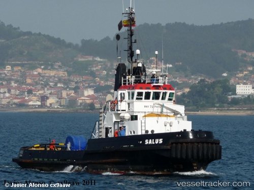
vessel Kadotug IMO: 7517052, Tug
vesseltracker.com
Vessel Kadotug IMO: 7517052, Tug
MMSI: 511100141 callsign: ERXT size: 31x9

Find the position of the vessel Kadotug on the map. The latter are known coordinates and path.

marine traffic ship tracker show on live map

The current position of vessel Kadotug is 58.6801 lat / 21.2365 lng. Updated: 2023-09-08 23:46:16 UTC

Currently sailing under the flag of Palau

Kadotug built in 1976 year

Deadweight:
10 t

Details:


Last coordinates of the vessel:
2023-09-08 23:46:16 UTC, 58.6801, 21.2365, course: 32, speed: 25.1

Track of the vessel in the last 14 days


Most frequent ports a vessels calls at Kadotug (511100141):

Istanbul, traffic: 17
Uskudar, traffic: 16
Novorossiysk, traffic: 4
Trabzon, traffic: 4
Zonguldak, traffic: 2
Batumi, traffic: 2
Canakkale, traffic: 2
Gelibolu, traffic: 2
Rhodes, traffic: 2
Constanta, traffic: 1

Link to the map:


Find another ship

Kadotug (511100141) last ports (portcalls and passsages)

Uskudar | 2022-11-19 05:20:48
Uskudar | 2022-09-04 02:11:44
Uskudar | 2022-08-31 01:52:45
Istanbul | 2022-08-27 01:11:41
Uskudar | 2022-08-23 01:06:11
Uskudar | 2022-08-18 22:38:38
Uskudar | 2022-08-14 22:15:34
Uskudar | 2022-08-10 20:05:18
Uskudar | 2022-08-06 19:16:06
Istanbul | 2022-07-06 07:27:17
Constanta | 2022-06-29 22:10:39
Uskudar | 2022-06-24 19:21:22
Gelibolu | 2022-06-23 10:19:48
Canakkale | 2022-06-23 05:06:40
Rhodes | 2022-06-18 22:53:29
Rhodes | 2022-06-07 22:07:14
Canakkale | 2022-06-04 13:12:51
Gelibolu | 2022-06-04 07:05:37
Uskudar | 2022-06-02 16:43:07
Novorossiysk | 2022-05-25 14:02:50
Novorossiysk | 2022-05-21 13:25:29
Novorossiysk | 2022-05-17 13:21:19
Novorossiysk | 2022-05-13 10:55:37
Trabzon | 2022-05-10 13:37:19
Trabzon | 2022-05-06 13:12:14
Trabzon | 2022-05-02 12:21:39
Trabzon | 2021-12-17 03:39:54
Batumi | 2021-12-13 10:30:28
Zonguldak | 2021-12-06 16:30:00
Istanbul | 2021-12-05 23:45:10
Istanbul | 2021-12-05 23:26:39
Uskudar | 2021-12-01 00:01:27