 vesseltracker.com
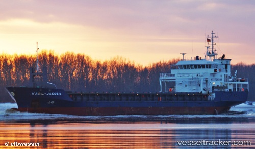
Vessel Karl Jakob K IMO: 9344409, MMSI: 244008000 General Cargo Ship
Live AIS position:
UTC. Near TUZLA),
updated 2025-04-03 11:48:50 UTC.
Find the position of the vessel Karl Jakob K on the map. The latter are known coordinates and path.
marine traffic ship tracker show on live map
The current position of vessel Karl Jakob K is 40.85161 lat / 29.28813 lng. Updated: 2025-04-03 11:48:50 UTCCurrently sailing under the flag of Netherlands
Karl Jakob K built in 2006 year
Deadweight:
4264 tDetails:
Last coordinates of the vessel:
2025-04-03 11:48:50 UTC, 40.85161, 29.28813, course: 255, speed: 0