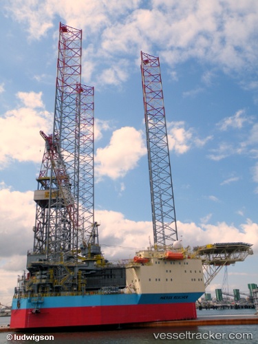
vessel Maersk Reacher IMO: 8768256, Service Ship
vesseltracker.com
Vessel Maersk Reacher IMO: 8768256, Service Ship
MMSI: 563468000 callsign: 9V9223 size: 103x68

Find the position of the vessel Maersk Reacher on the map. The latter are known coordinates and path.

marine traffic ship tracker show on live map

The current position of vessel Maersk Reacher is 55.4803352355957 lat / 5.107500076293945 lng. Updated: 2023-09-12 14:15:01 UTC

Currently sailing under the flag of Singapore

Maersk Reacher built in 2009 year

Deadweight:
5018 t

Details:


Last coordinates of the vessel:
2023-09-12 14:15:01 UTC, 55.4803352355957, 5.107500076293945, course: -1, speed: 0

Track of the vessel in the last 14 days


Most frequent ports a vessels calls at Maersk Reacher (563468000):

Frederikshavn, traffic: 10
Skagens Odde, traffic: 1

Link to the map:


Find another ship

Maersk_Reacher (563468000) last ports (portcalls and passsages)

Skagens Odde | 2022-06-07 04:05:12
Frederikshavn | 2022-06-03 22:33:24
Frederikshavn | 2022-05-30 19:55:46
Frederikshavn | 2022-05-26 16:50:11
Frederikshavn | 2022-05-22 16:37:58
Frederikshavn | 2022-05-18 16:26:44
Frederikshavn | 2022-05-14 13:48:03
Frederikshavn | 2022-05-10 13:31:01
Frederikshavn | 2022-05-06 13:19:29
Frederikshavn | 2022-05-02 12:51:50
Frederikshavn | 2022-03-07 08:36:36