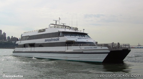
 NANTUCKET_EXPRESS
Current Status
Where is the vessel?
NANTUCKET_EXPRESS is currently in Near NANTUCKET, based on AIS data received about 15h ago.
Latest AIS update:
Current position: 41.36203° N, 70.13643° W (Near NANTUCKET)
Average speed (last 7 days): Loading…
Average speed (last 30 days): Loading…
Vessel profile: NANTUCKET_EXPRESS is a Passengers Ship with dimensions m x m.
This page combines live AIS, route history, probable destination signals, nearby traffic, and port activity for practical vessel monitoring.
The current position of vessel NANTUCKET_EXPRESS is 41.36203 lat / -70.13643 lng. Updated: 2026-05-23 15:32:52 UTCNearest reference points:
- Near South Yarmouth
- Near Barnstable
- Near VINEYARD HAVEN
Currently sailing under the flag of United States ![]()
Details:
Live Vessel NANTUCKET_EXPRESS Analytics (details, animations, etc.)
Recent AIS points (UTC):
2026-05-23 12:15:00 UTC · 41.62140, -70.91345 · SOG 0 kn · COG 168°2026-05-23 13:12:25 UTC · 41.62340, -70.90533 · SOG 13.8 kn · COG 157°
2026-05-23 13:43:19 UTC · 41.49441, -70.60401 · SOG 29.6 kn · COG 105°
2026-05-23 15:32:52 UTC · 41.36203, -70.13643 · SOG 28.4 kn · COG 327°