 vesseltracker.com
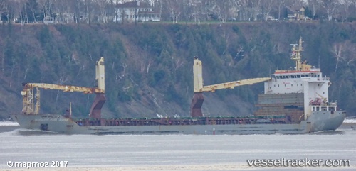
Vessel Nomadic Hjellestad IMO: 9452220, MMSI: 538007669 Multi Purpose Carrier
UTC, 10.01536, -86.63648, course: 130, speed: 8.3
UTC, 9.76913, -86.37989, course: 126, speed: 7.8
2026-02-09 01:09:51 UTC, 9.63184, -86.23104, course: 132, speed: 8.8
Live AIS position:
UTC. 40 nm SW of Nosara Beach),
updated 2026-02-09 01:09:51 UTC.
Find the position of the vessel Nomadic Hjellestad on the map. The latter are known coordinates and path.
marine traffic ship tracker show on live map
The current position of vessel Nomadic Hjellestad is 9.63184 lat / -86.23104 lng. Updated: 2026-02-09 01:09:51 UTCCurrently sailing under the flag of Marshall Is
Nomadic Hjellestad built in 2010 year
Deadweight:
12940 tDetails:
Last coordinates of the vessel:
UTC, 10.15105, -86.78771, course: 118, speed: 7.2UTC, 10.01536, -86.63648, course: 130, speed: 8.3
UTC, 9.76913, -86.37989, course: 126, speed: 7.8
2026-02-09 01:09:51 UTC, 9.63184, -86.23104, course: 132, speed: 8.8