 vesseltracker.com
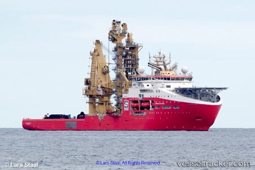
Vessel Normand Maximus IMO: 9744518, MMSI: 258987000 Offshore Support Vessel
UTC, -25.51667, -43.46833, course: -1, speed: 0
UTC, -25.51768, -43.46946, course: 30, speed: 0.2
2026-02-12 14:33:52 UTC, -25.51770, -43.46946, course: 31, speed: 0
Live AIS position:
UTC. 34 nm W of Cidade de Angra dos Reis FPSO),
updated 2026-02-12 14:33:52 UTC.
Find the position of the vessel Normand Maximus on the map. The latter are known coordinates and path.
marine traffic ship tracker show on live map
The current position of vessel Normand Maximus is -25.51770 lat / -43.46946 lng. Updated: 2026-02-12 14:33:52 UTCCurrently sailing under the flag of Norway
Details:
Last coordinates of the vessel:
UTC, -25.51667, -43.46833, course: -1, speed: 0UTC, -25.51667, -43.46833, course: -1, speed: 0
UTC, -25.51768, -43.46946, course: 30, speed: 0.2
2026-02-12 14:33:52 UTC, -25.51770, -43.46946, course: 31, speed: 0