 vesseltracker.com
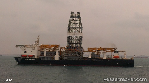
Vessel Ocean Blackhawk IMO: 9618898, MMSI: 538005061 Drilling Ship
UTC, 26.07888, -92.05965, course: 355, speed: 0.1
UTC, 26.07887, -92.05963, course: 355, speed: 0.2
2026-01-27 03:13:16 UTC, 26.07887, -92.05964, course: 355, speed: 0.1
Live AIS position:
UTC. 120 nm SW of Gulfmex Lightering Area),
updated 2026-01-27 03:13:16 UTC.
Find the position of the vessel Ocean Blackhawk on the map. The latter are known coordinates and path.
marine traffic ship tracker show on live map
The current position of vessel Ocean Blackhawk is 26.07887 lat / -92.05964 lng. Updated: 2026-01-27 03:13:16 UTCDetails:
Last coordinates of the vessel:
UTC, 26.07888, -92.05965, course: 354, speed: 0UTC, 26.07888, -92.05965, course: 355, speed: 0.1
UTC, 26.07887, -92.05963, course: 355, speed: 0.2
2026-01-27 03:13:16 UTC, 26.07887, -92.05964, course: 355, speed: 0.1