 vesseltracker.com
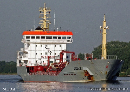
Vessel Paul E IMO: 9268277, MMSI: 236283000 Chemical Oil Products Tanker
UTC, 54.28388, 9.64220, course: 221, speed: 6.5
UTC, 54.11452, 9.32850, course: 175, speed: 7.1
2026-01-31 04:34:50 UTC, 53.89338, 9.14478, course: 228, speed: 0
Live AIS position:
UTC. Near Kiel Canal),
updated 2026-01-31 04:34:50 UTC.
Find the position of the vessel Paul E on the map. The latter are known coordinates and path.
marine traffic ship tracker show on live map
The current position of vessel Paul E is 53.89338 lat / 9.14478 lng. Updated: 2026-01-31 04:34:50 UTCCurrently sailing under the flag of Gibraltar
Paul E built in 2005 year
Deadweight:
6974 tDetails:
Last coordinates of the vessel:
UTC, 54.34175, 9.95588, course: 261, speed: 7.3UTC, 54.28388, 9.64220, course: 221, speed: 6.5
UTC, 54.11452, 9.32850, course: 175, speed: 7.1
2026-01-31 04:34:50 UTC, 53.89338, 9.14478, course: 228, speed: 0