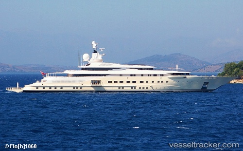
vessel Pelorus IMO: 8977273, Service Ship
Vessel Pelorus IMO: 8977273, Service Ship
MMSI: 319029200 callsign: ZGBO3 size: 18x115

Find the position of the vessel Pelorus on the map. The latter are known coordinates and path.

marine traffic ship tracker show on live map

The current position of vessel Pelorus is 53.8433 lat / 9.41166 lng. Updated: 2024-06-17 07:01:06 UTC
Home port:
George Town (capital and largest city of the Cayman Islands)
Port of registry:
George Town (capital and largest city of the Cayman Islands)
Speed:
20 knot
Powered by:
diesel engine (internal combustion engine with quality rotational frequency governing, internal mixture formation, lean air-fuel-ratio, diffusion flame and compression ignition)
Gross tonnage:
5403
Beam:
17.2 metre
Service entry:
2003-01-01T00:00:00Z

Manufacturer:
Lürssen (German shipbuilding company)


Owned:
Abdullah bin Zayed Al Nahyan (United Arab Emirates minister of foreign affairs)

Details:


Last coordinates of the vessel:
2024-06-17 07:01:06 UTC, 53.8433, 9.41166, course: 84, speed: 0

Track of the vessel in the last 14 days


Most frequent ports a vessels calls at Pelorus (319029200):

Lisboa, traffic: 2
Lisbon, traffic: 2
Skelleftehamn, traffic: 2
Zelinika, traffic: 2
Algeciras, traffic: 2
Burea, traffic: 2
Emden, traffic: 1
Cuxhaven, traffic: 1

Link to the map:


Find another ship

Pelorus (319029200) last ports (portcalls and passsages)

Emden | 2024-05-28 10:41:28
Skelleftehamn | 2023-08-05 23:43:38
Skelleftehamn | 2023-06-21 00:30:41
Cuxhaven | 2022-03-10 21:15:09
Lisboa | 2022-02-17 03:05:55
Algeciras | 2022-02-16 00:06:17
Zelinika | 2022-01-15 09:45:06