 vesseltracker.com
Find the position of the vessel RUSSKIY VOSTOK on the map. The latter are known coordinates and path.
marine traffic ship tracker show on live map
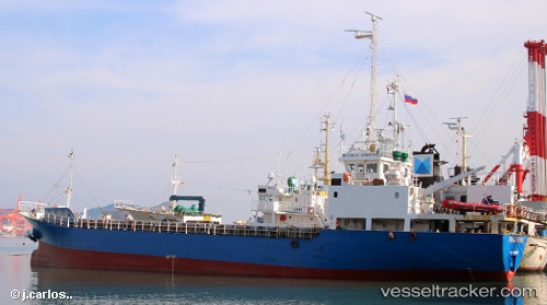
The current position of vessel RUSSKIY VOSTOK is 46.63963 lat / 142.49358 lng. Updated: 2025-11-14 06:52:37 UTCCurrently sailing under the flag of Russia
RUSSKIY VOSTOK built in 1991 year
Deadweight:
697 tDetails:
Last coordinates of the vessel:
UTC, 46.63957, 142.49347, course: -1, speed: 0.1UTC, 46.63963, 142.49358, course: -1, speed: 0
UTC, 46.63963, 142.49358, course: -1, speed: 0
2025-11-14 06:52:37 UTC, 46.63963, 142.49358, course: -1, speed: 0
Track of the vessel in the last 14 days
The ship also appears on the maps:
- Моя рабочая карта
- Курилы
- ЮК Пассажиры + Грузовики
- ЮК промысловая зона - 1
- ЮК промысловый район -2
- ЮК промысловая зона - 3
- ЮК промысловая зона - 4
- Южные Курилы
- Моя карта 0924
- YK 11.2024
- YK 1124
- Южные Курилы - 5
- Южные Курилы - 6
- Южные Курилы - 1
- Южные Курилы - 1
- Южные Курилы - 2
- Южные Курилы - 3
- Moya karta
- YK 070925
- Russkiy Vostok