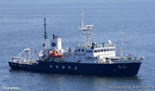
vessel Tam Yang IMO: 8875906, Research Vessel
Vessel Tam Yang IMO: 8875906, Research Vessel
MMSI: 440311000 callsign: DSAA6 size: 11x52

Find the position of the vessel Tam Yang on the map. The latter are known coordinates and path.

marine traffic ship tracker show on live map

The current position of vessel Tam Yang is 38.2106 lat / 128.595 lng. Updated: 2024-04-19 17:39:54 UTC
Details:


Last coordinates of the vessel:
UTC, 38.2106, 128.595, course: -1, speed: 0.1
2024-04-19 17:39:54 UTC, 38.2106, 128.595, course: -1, speed: 0.1

Track of the vessel in the last 14 days


Most frequent ports a vessels calls at Tam Yang (440311000):

Busan, traffic: 10
Bohang, traffic: 2
Pohang, traffic: 2

Link to the map:


Find another ship

Tam_Yang (440311000) last ports (portcalls and passsages)

Pohang | 2023-05-27 07:20:00
Busan | 2023-05-11 02:29:46
Busan | 2023-04-28 03:52:06
Busan | 2022-11-15 11:30:01
Pohang | 2022-11-02 11:22:14
Busan | 2022-07-12 01:47:54
Busan | 2022-07-07 22:44:42
Busan | 2022-07-03 22:42:45
Busan | 2022-06-29 13:15:50
Busan | 2022-06-25 11:06:50
Busan | 2022-06-21 10:38:50
Busan | 2022-06-17 10:05:51