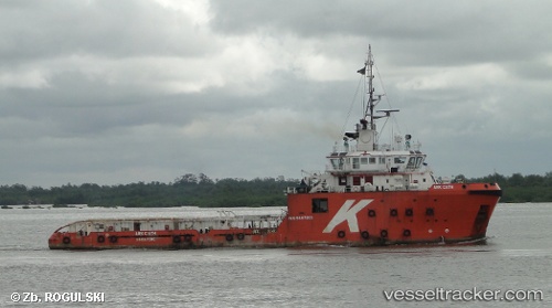
vessel Tan Cang 89 IMO: 9487201, Offshore Tug Supply Ship
vesseltracker.com
Vessel Tan Cang 89 IMO: 9487201, Offshore Tug Supply Ship
MMSI: 574003330 callsign: XVWK9 size: 16x67

Find the position of the vessel Tan Cang 89 on the map. The latter are known coordinates and path.

marine traffic ship tracker show on live map

The current position of vessel Tan Cang 89 is 7.9116666666667 lat / 102.81999833333 lng. Updated: 2025-11-03 12:00:35 UTC
Details:


Last coordinates of the vessel:
UTC, 7.955, 102.665, course: -1, speed: 6
2025-11-03 12:00:35 UTC, 7.9116666666667, 102.81999833333, course: -1, speed: 0

Track of the vessel in the last 14 days


Most frequent ports a vessels calls at Tan Cang 89 (574003330):

Vung Tau, traffic: 10
Cape St. Jacques, traffic: 9
Nha Be, traffic: 6
Gemalink, traffic: 6
Sambu, traffic: 3
Cai Mep, traffic: 3
Ho Chi Minh, traffic: 2
Singapore, traffic: 2
PRACHUAP, traffic: 1

Link to the map:


Find another ship

Tan_Cang_89 (574003330) last ports (portcalls and passsages)

PRACHUAP | 2024-11-08 07:01:17
Vung Tau | 2023-12-22 00:58:49
Vung Tau | 2023-12-15 21:01:23
Vung Tau | 2023-12-11 10:33:07
Vung Tau | 2023-12-01 03:22:38
Cai Mep | 2023-11-28 16:09:48
Cai Mep | 2023-11-06 15:25:43
Cai Mep | 2023-10-30 06:54:05
Vung Tau | 2023-10-30 03:12:37
Sambu | 2023-09-27 22:35:18
Sambu | 2023-09-23 22:32:43
Singapore | 2023-09-20 05:22:38
Singapore | 2023-09-16 04:08:23
Vung Tau | 2022-06-15 07:25:51
Gemalink | 2022-06-02 10:06:18
Vung Tau | 2022-06-02 07:36:27
Vung Tau | 2022-04-03 18:25:05
Nha Be | 2022-01-05 13:40:51
Nha Be | 2022-01-05 13:00:51
Nha Be | 2022-01-05 12:20:51
Gemalink | 2022-01-05 10:11:37
Vung Tau | 2022-01-05 07:45:51