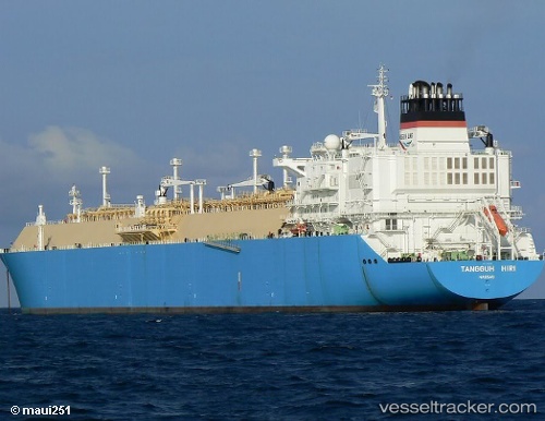
vessel Tangguh Hiri IMO: 9333632, Lng Tanker
vesseltracker.com
Vessel Tangguh Hiri IMO: 9333632, Lng Tanker
MMSI: 309787000 callsign: C6XC2 size: 288x288

Find the position of the vessel Tangguh Hiri on the map. The latter are known coordinates and path.

marine traffic ship tracker show on live map

The current position of vessel Tangguh Hiri is 2.52167 lat / 129.30333 lng. Updated: 2025-11-04 03:50:03 UTC

Currently sailing under the flag of Bahamas

Tangguh Hiri built in 2008 year

Deadweight:
84467 t

Details:


Last coordinates of the vessel:
UTC, 2.33167, 129.36833, course: -1, speed: 9
UTC, 2.16667, 129.30333, course: -1, speed: 9
UTC, 2.40667, 129.28833, course: -1, speed: 11
2025-11-04 03:50:03 UTC, 2.52167, 129.30333, course: -1, speed: 11

Track of the vessel in the last 14 days


The ship also appears on the maps:


Most frequent ports a vessels calls at Tangguh Hiri (309787000):

Yosu, traffic: 12
Yeosu, traffic: 12
Yokosuka, traffic: 7
TANGGUH, traffic: 7
Sambu, traffic: 6
Singapore, traffic: 6
Higashi-Iwase, traffic: 5
BITUNG, traffic: 5
Osaka, traffic: 4
Barrow Island, traffic: 4
PULAU SAMBU, traffic: 3
Kawasaki, traffic: 3
Port Darwin, traffic: 3
TANAH MERAH, traffic: 3
Darwin, traffic: 3

Link to the map:


Find another ship

Tangguh_Hiri (309787000) last ports (portcalls and passsages)

HIMEJI | 2025-08-10 20:58:11
AKASHI | 2025-08-10 18:58:45
KADA | 2025-08-10 15:08:50
TANGGUH | 2025-08-02 23:59:53
Yosu | 2025-07-18 23:59:05
TANGGUH | 2025-07-10 22:59:40
BITUNG | 2025-06-30 02:23:30
BITUNG | 2025-06-26 01:15:28
BITUNG | 2025-06-22 00:44:21
BITUNG | 2025-06-18 00:02:43
Yosu | 2025-05-11 23:59:38
TANGGUH | 2025-04-23 09:55:10
TANAH MERAH | 2025-04-15 06:10:56
PULAU SAMBU | 2025-04-15 05:04:27
JURONG ISLAND | 2025-04-11 04:01:10
BUKOM ISLAND | 2025-04-11 03:26:32
PULAU SAMBU | 2025-04-11 01:55:02
TANAH MERAH | 2025-04-11 01:21:17
Yosu | 2025-04-01 23:59:17
TANGGUH | 2025-03-13 19:30:55
Yosu | 2025-03-01 23:59:07
TANGGUH | 2025-02-19 06:26:37
KIMITSU | 2025-02-01 03:59:01
Yokosuka | 2025-02-01 02:58:45
TANGGUH | 2025-01-20 23:35:20
ONSAN | 2025-01-05 00:53:13
TANGGUH | 2024-12-25 08:21:41
BITUNG | 2024-12-11 01:14:24
BATU AMPAR | 2024-11-29 01:18:41
BUKOM ISLAND | 2024-11-27 04:08:08
PULAU SAMBU | 2024-11-27 02:54:32
TANAH MERAH | 2024-11-27 01:41:16
PENGERANG | 2024-11-27 01:25:23
SAKAI | 2024-11-09 03:10:58
KADA | 2024-11-08 23:53:59
Singapore | 2024-09-05 03:38:33
Map Ta Phut | 2024-09-01 05:36:24
Yosu | 2024-08-14 23:33:29
Selat Wetar | 2024-07-18 00:56:46
Port Darwin | 2024-07-15 22:39:13
Osaka | 2024-06-29 01:24:54
Singapore | 2024-05-14 02:35:02
Yosu | 2024-04-30 23:51:21
Yosu | 2024-02-22 11:01:13
Port Darwin | 2024-02-04 22:06:00
Yosu | 2024-01-26 23:58:49
Osaka | 2023-12-25 03:05:56
Yosu | 2023-11-11 23:59:37
Higashi-Iwase | 2023-09-05 23:04:20
Yokosuka | 2023-08-17 06:58:12
Yosu | 2023-06-08 03:24:57
Yosu | 2023-05-03 00:52:40
Yosu | 2023-04-29 00:19:31
Higashi-Iwase | 2023-04-01 04:12:10
Osaka | 2023-02-13 05:24:51
Higashi-Iwase | 2023-01-20 05:27:52
Yokosuka | 2022-11-14 02:03:56
Yokohama | 2022-10-26 01:03:25
Port Darwin | 2022-10-12 22:31:15
Ambon | 2022-08-27 02:02:16
Thursday Island | 2022-07-10 14:10:12
Yokkaichi | 2022-06-30 01:02:05
Higashi-Iwase | 2022-06-02 22:03:32
Singapore | 2022-05-13 07:18:10
Sambu | 2022-05-11 01:58:17
Ambon | 2022-03-07 04:03:03
Barrow Island | 2022-02-09 05:50:43
Yokosuka | 2022-01-15 05:40:19
Kawasaki | 2022-01-15 05:05:28
Yokosuka | 2022-01-14 03:05:47
Barrow Island | 2022-01-03 03:05:37
Selat Lombok | 2021-12-02 20:26:45