 vesseltracker.com
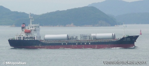
Vessel Ty Iris IMO: 9400435, MMSI: 440629000 General Cargo Ship
UTC, 35.05530, 129.06068, course: 315, speed: 0.2
UTC, 35.05531, 129.06091, course: 296, speed: 0.1
2026-02-06 18:06:10 UTC, 35.05513, 129.06087, course: 307, speed: 0.3
Live AIS position:
UTC. Near Busan),
updated 2026-02-06 18:06:10 UTC.
Find the position of the vessel Ty Iris on the map. The latter are known coordinates and path.
marine traffic ship tracker show on live map
The current position of vessel Ty Iris is 35.05513 lat / 129.06087 lng. Updated: 2026-02-06 18:06:10 UTCCurrently sailing under the flag of Korea
Details:
Last coordinates of the vessel:
UTC, 35.05572, 129.06087, course: 274, speed: 0.1UTC, 35.05530, 129.06068, course: 315, speed: 0.2
UTC, 35.05531, 129.06091, course: 296, speed: 0.1
2026-02-06 18:06:10 UTC, 35.05513, 129.06087, course: 307, speed: 0.3