vessel Via Mare IMO: 7411258, Passenger Ro Ro Cargo Ship
Vessel Via Mare IMO: 7411258, Passenger Ro Ro Cargo Ship
MMSI: 271055018 callsign: TCA9018 size: 118x20

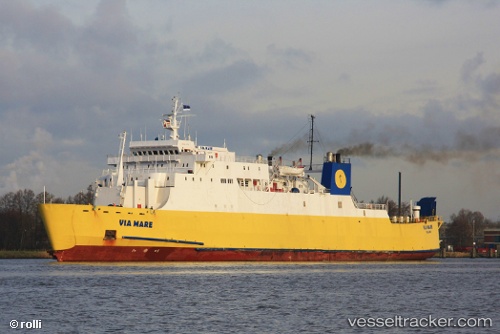
Find the position of the vessel Via Mare on the map. The latter are known coordinates and path.

marine traffic ship tracker show on live map

The current position of vessel Via Mare is 35.3427 lat / 33.3351 lng. Updated: 2024-04-25 09:41:05 UTC

Currently sailing under the flag of Turkey

Via Mare built in 1976 year

Port of registry:
London (capital and largest city of England and the United Kingdom)
Deadweight:
3927 t

Gross tonnage:
8023
Service entry:
1976-01-01T00:00:00Z

Manufacturer:
Schichau Unterweser (shipyard)

Owned:
European Ferries
Details:


Last coordinates of the vessel:
UTC, 35.3427, 33.3351, course: 143, speed: 0
2024-04-25 09:41:05 UTC, 35.3427, 33.3351, course: 143, speed: 0

Track of the vessel in the last 14 days


Most frequent ports a vessels calls at Via Mare (271055018):

Famagusta, traffic: 19
Mersin, traffic: 8

Link to the map:


Find another ship

Via_Mare (271055018) last ports (portcalls and passsages)

Famagusta | 2024-01-14 05:46:24
Mersin | 2024-01-13 08:05:26
Famagusta | 2023-11-27 21:10:35
Famagusta | 2023-11-23 20:38:04
Famagusta | 2023-11-19 20:24:41
Famagusta | 2023-11-15 19:23:51
Famagusta | 2023-11-11 18:25:04
Famagusta | 2023-11-07 16:59:53
Famagusta | 2023-09-22 20:20:41
Famagusta | 2023-09-18 19:20:43
Famagusta | 2023-08-12 13:25:41
Famagusta | 2023-08-08 12:49:31
Famagusta | 2023-08-04 12:31:02
Famagusta | 2023-07-28 11:30:48
Famagusta | 2023-03-29 07:54:44
Mersin | 2023-03-28 11:13:31
Famagusta | 2023-02-22 08:48:59
Mersin | 2023-02-18 08:42:14
Mersin | 2023-02-11 11:47:06
Mersin | 2023-02-07 08:41:01
Mersin | 2022-10-22 07:55:47
Mersin | 2022-02-10 12:35:47
Famagusta | 2022-01-03 00:43:36