.

Port Isla Mayor

Recent vessels visits to the port and vessels passing by the port in recent times (indicative data).
On the page of each ship you can see which ports it called.

Contact details, port services, terminals, warehouses, cranes, logistics, surveying and other services will be progressively added and updated.
(If you are a representative of the port, and you want to add information, write to us by mail: info[at]shipinfo.net)

Recent vessels near the port (coming in or passing by):

(01-18 10:20) Multi Purpose Carrier Bbc-Vesuvius
     IMO: 9508471, MMSI: 305865000

vessel Bbc Vesuvius IMO: 9508471, Multi Purpose Carrier
vesseltracker.com
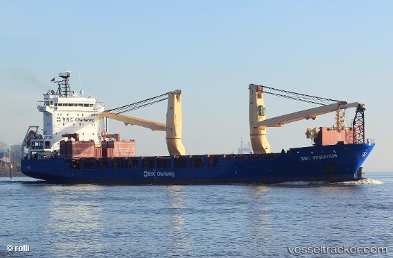
Vessel Bbc Vesuvius IMO: 9508471, MMSI: 305865000 Multi Purpose Carrier

callsign: V2GB4
size: 125x22

Live AIS position: UTC. 18 nm S of Punta Umbría), updated 2026-01-18 15:58:42 UTC.

Find the position of the vessel Bbc Vesuvius on the map. The latter are known coordinates and path.

marine traffic ship tracker show on live map

The current position of vessel Bbc Vesuvius is 36.87012 lat / -6.88005 lng. Updated: 2026-01-18 15:58:42 UTC

Currently sailing under the flag of Antigua Barbuda

Bbc Vesuvius built in 2012 year

Deadweight:
9310 t

Details:


Last coordinates of the vessel:
2026-01-18 15:58:42 UTC, 36.87012, -6.88005, course: 46, speed: 0.1

Track of the vessel in the last 28 days


Shipping companies (lines) whose ships most often called at the port Isla Mayor:

Naviera Murueta SA, traffic: 1

Frequent port vessels:

Types of vessels calling at the seaport Isla Mayor:


You can see the routes between any ports here. List of ships that go between given ports (marine traffic).


Link to the map:


Find another ship

Recent vessel arrivals at the port

Estimated data
01-18 10:20 Bbc-Vesuvius
IMO: 9508471, MMSI: 305865000 | Multi Purpose Carrier

Top routes from the port Isla Mayor