.
vessel TETHYS IMO: 9427536, Chemical/Oil Products Tanker vesseltracker.com
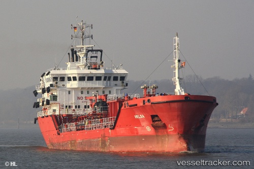
Vessel TETHYS IMO: 9427536, MMSI: 210260000 Chemical/Oil Products Tanker

callsign: 5BVA5
size: x

Live AIS position: UTC. Near Las Palmas de Gran Canaria), updated 2026-01-17 15:27:17 UTC.

Find the position of the vessel TETHYS on the map. The latter are known coordinates and path.

marine traffic ship tracker show on live map

The current position of vessel TETHYS is 28.11653 lat / -15.40564 lng. Updated: 2026-01-17 15:27:17 UTC

Currently sailing under the flag of Cyprus

TETHYS built in 2012 year

Deadweight:
4393 t

Details:


Last coordinates of the vessel:
UTC, 28.15709, -15.39855, course: 180, speed: 0
UTC, 28.15713, -15.39855, course: 180, speed: 0
UTC, 28.15706, -15.39859, course: 180, speed: 0
2026-01-17 15:27:17 UTC, 28.11653, -15.40564, course: 338, speed: 3


Most frequent ports a vessels calls at TETHYS (210260000):

Genova, traffic: 4
Horta, traffic: 2
Valencia, traffic: 2
Kingstown, traffic: 2
Puerto De La Luz, traffic: 2
Tompkinsville, traffic: 1
Jersey City, traffic: 1
Algeciras, traffic: 1
Las Palmas, traffic: 1
Bayonne, traffic: 1
New York, traffic: 1
Boston, traffic: 1
Newark, traffic: 1
Brooklyn, traffic: 1
Palma, traffic: 1

Link to the map:


Find another ship

TETHYS (210260000) last ports (portcalls and passsages)

Genova | 2022-12-30 20:44:12
Genova | 2022-12-26 17:43:08
Genova | 2022-12-22 15:04:56
Genova | 2022-10-10 04:45:21
Palma | 2022-09-24 19:18:09
Valencia | 2022-09-23 04:20:06
Valencia | 2022-09-03 01:52:41
Algeciras | 2022-08-30 07:03:12
Gibraltar | 2022-08-29 23:18:33
Ponta Delgada | 2022-08-24 07:15:39
Horta | 2022-08-22 13:49:17
Horta | 2022-08-18 13:39:18
Boston | 2022-06-15 19:39:46
Cape Cod Canal | 2022-06-15 13:25:53
Port Newark | 2022-06-11 16:13:57
Tompkinsville | 2022-06-11 01:16:51
Plymouth | 2022-03-10 03:00:47
Kingstown | 2021-12-31 15:20:00
Puerto De La Luz | 2021-12-06 09:22:58