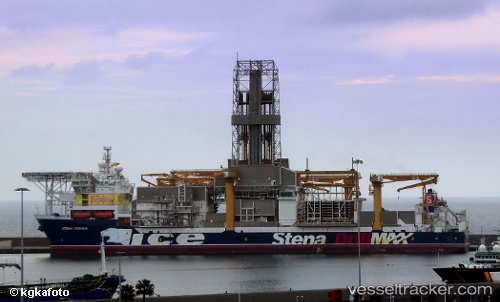
vessel Stena Icemax IMO: 9517575, Drilling Ship
vesseltracker.com
Vessel Stena Icemax IMO: 9517575, Drilling Ship
MMSI: 235092459 callsign: 2FMJ5 size: 42x228
Live AIS position: 28.14167° N, 15.40833° W UTC. Near Las Palmas), updated 2025-11-19 18:41:39 UTC.

Find the position of the vessel Stena Icemax on the map. The latter are known coordinates and path.

marine traffic ship tracker show on live map

The current position of vessel Stena Icemax is 28.14167 lat / -15.40833 lng. Updated: 2025-11-19 18:41:39 UTC
Details:


Last coordinates of the vessel:
UTC, 28.14167, -15.40833, course: -1, speed: 0
UTC, 28.14217, -15.40817, course: 1, speed: 0
UTC, 28.14217, -15.40817, course: 1, speed: 0.1
2025-11-19 18:41:39 UTC, 28.14167, -15.40833, course: -1, speed: 0


Most frequent ports a vessels calls at Stena Icemax (235092459):

Puerto De La Luz, traffic: 8
Las Palmas, traffic: 7
Strait Of Gibraltar, traffic: 1

Link to the map:


Find another ship

Stena_Icemax (235092459) last ports (portcalls and passsages)

Puerto De La Luz | 2023-04-18 11:24:37
Puerto De La Luz | 2023-04-13 10:15:51
Puerto De La Luz | 2023-04-09 10:03:49
Puerto De La Luz | 2023-04-03 04:54:28
Puerto De La Luz | 2023-03-30 04:22:17
Puerto De La Luz | 2023-01-08 08:24:44
Puerto De La Luz | 2023-01-04 06:32:21
Strait Of Gibraltar | 2022-12-31 08:25:54
Puerto De La Luz | 2022-01-01 10:10:14